
The Keystone Thrust in Red Rock Canyon NCA is a good example of plate tectonic activity that happened about 65 million years ago when the surface of the earth cracked and older rocks slid over and covered younger deposited rocks. This is such a vivid example of plate movement that is has been featured in various textbooks.
The Keystone Thrust trailhead is reached by following the Red Rock Scenic Loop about 5.5 miles from the Visitor Center to White Rock Mountain Road. Many people without a high-clearance vehicle park at the junction, but is is possible to follow a rocky, dirt trail for about another 0.5 miles to the actual trailhead. The trailhead is located at the southeast corner of White Rock Mountain and follows the White Rock Loop Trail to the north for a short distance.
This is a relatively easy hike, but can be extended by adding some additional off-trail adventures.
A short distance from the trailhead there is an Agave Roasting Pit that was used by Native Americans to cook foods by heating stones in a pit and then placing meats and vegetables in the pit and covering everything for a period of time (similar to a Hawaiian Imu). There is a sign adjacent to the trail that provides additional information about the pit.


After passing the Agave Roasting pit, the trail continues north for about 0.1 miles and then the Keystone Thrust Trail turns east and goes up some steps, while the White Rock Loop Trail continues to the north.


After about 0.5 miles the trail turns right into Keystone Basin; but we were not in a hurry, so we followed an old trail that continued up the hill to a limestone outcropping that provided spectacular views of Turtle Head Mountain to the east and we could also look down at the Keystone Thrust.


After backtracking to the Keystone Basin Junction, it was only a short hike down to the fault area. Apparently, this is still an active fault area because we found sandstone rocks that were pushed up in a number of different shapes and designs.


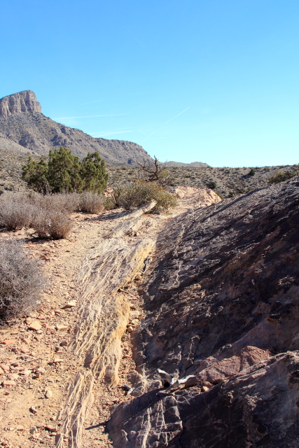
Rather than following the trail back to the parking lot, we decided to follow a drainage that went to the southwest past an area that distinctly showed the junction of the two plates.


Continuing down the canyon, there were a number of interesting geological formations (some covered with lichen) and when we looked back up the canyon we could see Sentinel Rock.


Lower in the canyon we encountered some white rocks that were scalloped with interesting designs from water erosion.


And finally, we reached the bottom of the canyon and we were able to hack our way through the brush back to the road. Great Adventure for our Arizona guest!


No comments:
Post a Comment