Friday, January 31, 2020

RonnieAdventure #0397- Gene's Loop Hike, Red Rock Canyon NCA, Nevada

Picture by Kolohe
Gene's Loop Hike starts on the east side of Calico Basin Road, less than 1/2 mile from State Highway 159. There are numerous trails in this area, so we decided to circle around and over the highest peak in the loop (peak in the background of the below picture). 


Looking back at the trailhead from the top of the first knoll. 


The peak is too steep to ascend from the west side, so the trail circles around to the east side of the mountain where there is a gradual incline to the peak. 


Although you would not know it now, this area was once covered with water. On the south side of the peak fossilized seaweed can be found covering many of the rocks.  


We even found a seashell!


Conglomerate and other seabed rocks were also strewn about the area. Some of the rocks contain large cuts from a later period in time when glaciers moved through the area.  


Various shades of lichen were also visible on the rocks. 


Lichen (multiple species are found in the area)
Part way up the east side of the mountain we found an old camp site and a pile of rocks that may have been a grave site. If it was a grave site, it was probably for an animal because it appeared to be too new for a human grave. 


Several trees in the area contained large growths of Mistletoe, which is a parasite. Wikipedia states "Mistletoe species grow on a wide range of host trees, some of which experience side effects including reduced growth, stunting, and loss of infested outer branches. A heavy infestation may also kill the host plant."


Mistletoe (Phoradendron leucarpum)
Unfortunately, we were too early in the year and none of the desert plants were in bloom. 

Strawberry Hedgehog Cactus (Echinocereus engelmannii)
Pencil Cholla Cactus (Opuntia ramosissima)
Mojave Yucca (Yucca schidigera)
Fishhook Cactus (Mammillaria tetrancistra)
Beavertail Cactus (Opuntia basilaris)
The Nevada Agave is also called a "Century Plant" because when the plant is about 10 years old it sends up a rapid-growing center stalk. The stalk shown below if from last year, but it just didn't fall over like most stock do after they die and dry up.

Nevada Agave (Agave utahensis)
The interior trunk of a Joshua Tree after it died.

Joshua Tree (Yucca brevifolia)
Continuing around the loop, the trail was fairly level until we reached the east-side trail that leads to the peak.  


Picture by Kolohe

Looking southeast toward Las Vegas. Red Rock Hotel/Casino is in the foreground. 


Just as we were finishing the hike, two horseback riders passed us going the other direction. 


Kolohe also provided me with some panoramic pictures!


BONUS HISTORICAL PICTURES 

I was really happy when my Mom made me a new snow suit. Years later, Grandsons Andrew and Carter also wore the snow suit. (She apparently added fur to the cap and jacket collar sometime between the pictures.)


Because my Mother did not have any daughters, and she liked to sew girls clothes, she also made me a girl's dress!


Friday, January 24, 2020

RonnieAdventure #0396 - Ash Canyon Loop Hike - Red Rock Canyon NCA, Clark County, Nevada

Panoramic Picture by Kolohe (Taken From Kraft Trailhead Looking Northwest)
From the Kraft Mountain Loop trailhead there are three mountain peaks visible to the northwest. Kraft Mountain is on the right and the loop trail around the mountain is probably the most popular hike in the area. The trail goes up to a saddle between the two most eastern mountains and then drops down into Gateway Canyon. Following Gateway Canyon to the east in a clockwise direction, the trail eventually winds around the mountain and ends up back at the trailhead. 

There is also an out-and-back trail that goes northwest to Ash Springs, which is located at the base of the westernmost mountain. 

Although not shown on the Red Rock Canyon NCA maps, a loop around the center mountain is delineated on one of the AllTrails maps. Therefore, we decided to follow the Kraft Trail Loop to Gateway Canyon and then go counterclockwise around the middle mountain for a great RonnieAdventure! 


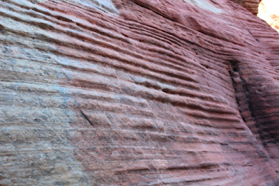
The hike to the saddle between the two mountains is steeper than it appears in the pictures, so we stopped several times for rest breaks and to take pictures of the unusual rock formations along the trail. (As I get older, some of the trails seem steeper than I remember them from the last time I hiked the trail.)


The below picture was taken from the saddle between the two mountains, looking back at the trailhead.


From the saddle, looking toward Gateway Canyon, Turtle Head Peak is visible in the background.


Hiking down to Gateway Canyon there were more unusual rock formations along the way.  


Walking in Gateway Canyon was fairly easy at first and we even encountered some snow in the shady areas.


However, when we came to the junction where we had to continue our counterclockwise loop, we found a lot of brush and rock in the canyon. After climbing over some rocks and winding our way around and through the brush, we eventually arrived at the saddle between the two most western mountains sporting a few unexpected cuts and scratches 


Picture by Kolohe

Mojave Yucca (Yucca schidigera)
Nevada Agave (Agave utahensis)
Barrel Cactus (Ferocactus acanthodes)


The view from the saddle was great, unfortunately, there was no trail leading down the canyon. That is when we realized it was going to require a lot of rock scrambling to get back to the trailhead. 

On our way down the canyon we encountered a number of Class III drops, but noting that required ropes or climbing gear.  

Picture by Kolohe
Picture by Kolohe
Although it took a lot longer than we had anticipated to work our way down the canyon, there were some interesting geological features along the way.


Looking back up the canyon that we had just descended. The rest of the hike back to the trailhead was mostly level terrain


BONUS HISTORICAL PICTURES (Jerry, Grandpa Welty, Ronnie)