Caliente
is located along the eastern boarder of Nevada and is the largest and only
incorporated community in Lincoln County. Lincoln County has a total land area
of 10,637 square miles and a total population of 5,345, people which equates to a
population density for the County of one person for every two square miles of land. However,
this represents a population increase of over 28% since the 2000 census
(population 4,165) when the population density was one person for every 2.55
square miles.
Most historians are of the opinion that the area now called Caliente was first settled in the early 1860s by Ike and Dow Barton, two slaves who had escaped from Arkansas. Although there are no accurate historical records, it is believed that Ike and Dow Barton built a stone house on the side of a hill and started ranching in the area. The stone house is still standing on Hill Street in Caliente, although there have been numerous additions and renovations to the existing structure.

In October 1864 Nevada was carved out of Utah Territory and became the 36th State admitted to the Union. However, it was not until 1866 when Congress enlarged the State of Nevada by moving the eastern boarder one degree of longitude eastward, which is how Caliente became part of Nevada.
In 1874 the Culverwell Family purchased land in the area and started supplying hay for the mining camps in Pioche and Delamar. As more people moved into the area, the community became known as Culverwell, but was later changed to “Calientes” because of the hot springs found in the area. When a post office was established, the “s” was dropped and the community became known as Caliente.
In the early 1900s, Caliente was a major railroad division line and the town had a population of over 5,000 residents. However, in the 1940s steam engines were replaced with diesel locomotives and the railroad division point was moved south to Las Vegas. Without the railroad jobs, the population of Caliente started declining and is now at 1,201 residents. However, the railroad is still very active with numerous trains passing through town each day.
The Caliente Mission-Style Union-Pacific Railroad Station located on Clover Street is probably one of the most recognized landmarks in Nevada. The Station was originally designed and constructed as a hotel, restaurant, telegraph office and train depot; but since the decline in rail passenger service, the building is currently used as Caliente’s City Hall, Library, and Art Museum. Adjacent to the Station building is the Caliente Boxcar Museum and other train cars, which contains memorabilia documenting Caliente’s railroad history.


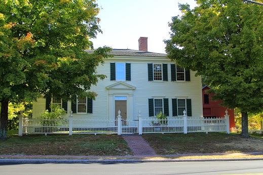
A walking tour guide of Caliente is available and gives a history of the rail station and other historic buildings located along the Clover Street Business District, including some old houses that were built into the side of a hill, the John Miller Buildings (designed as a bank with a hotel on the second floor, but used as the “Bucket of Blood Saloon” as well as a variety of other “lively” uses), other commercial buildings, houses, and the Rock Apartments.


Located on the-other-side-of-the-tracks is the Classic Box-Style Caliente Stone School (built in 1905), which is now used as the Caliente Methodist Church.

Located east of town on Barnes Canyon Road are some interesting cone shaped geological features called “Tee Pee Rocks.” There are several shallow water crossings on Clover Creek Road leading from Caliente to Barns Canyon (about 4.5 miles), but the crossings are generally shallow and four-wheel drive is not required.


Rainbow Canyon, with all of its beautiful Cottonwood Trees, is located south of Caliente, but we only had time for a short visit. Rainbow Canyon will have to be another RonnieAdventure when we have more time!
Most historians are of the opinion that the area now called Caliente was first settled in the early 1860s by Ike and Dow Barton, two slaves who had escaped from Arkansas. Although there are no accurate historical records, it is believed that Ike and Dow Barton built a stone house on the side of a hill and started ranching in the area. The stone house is still standing on Hill Street in Caliente, although there have been numerous additions and renovations to the existing structure.
In October 1864 Nevada was carved out of Utah Territory and became the 36th State admitted to the Union. However, it was not until 1866 when Congress enlarged the State of Nevada by moving the eastern boarder one degree of longitude eastward, which is how Caliente became part of Nevada.
In 1874 the Culverwell Family purchased land in the area and started supplying hay for the mining camps in Pioche and Delamar. As more people moved into the area, the community became known as Culverwell, but was later changed to “Calientes” because of the hot springs found in the area. When a post office was established, the “s” was dropped and the community became known as Caliente.
In the early 1900s, Caliente was a major railroad division line and the town had a population of over 5,000 residents. However, in the 1940s steam engines were replaced with diesel locomotives and the railroad division point was moved south to Las Vegas. Without the railroad jobs, the population of Caliente started declining and is now at 1,201 residents. However, the railroad is still very active with numerous trains passing through town each day.
The Caliente Mission-Style Union-Pacific Railroad Station located on Clover Street is probably one of the most recognized landmarks in Nevada. The Station was originally designed and constructed as a hotel, restaurant, telegraph office and train depot; but since the decline in rail passenger service, the building is currently used as Caliente’s City Hall, Library, and Art Museum. Adjacent to the Station building is the Caliente Boxcar Museum and other train cars, which contains memorabilia documenting Caliente’s railroad history.
A walking tour guide of Caliente is available and gives a history of the rail station and other historic buildings located along the Clover Street Business District, including some old houses that were built into the side of a hill, the John Miller Buildings (designed as a bank with a hotel on the second floor, but used as the “Bucket of Blood Saloon” as well as a variety of other “lively” uses), other commercial buildings, houses, and the Rock Apartments.
Located on the-other-side-of-the-tracks is the Classic Box-Style Caliente Stone School (built in 1905), which is now used as the Caliente Methodist Church.
Located east of town on Barnes Canyon Road are some interesting cone shaped geological features called “Tee Pee Rocks.” There are several shallow water crossings on Clover Creek Road leading from Caliente to Barns Canyon (about 4.5 miles), but the crossings are generally shallow and four-wheel drive is not required.
Rainbow Canyon, with all of its beautiful Cottonwood Trees, is located south of Caliente, but we only had time for a short visit. Rainbow Canyon will have to be another RonnieAdventure when we have more time!