Friday, April 30, 2021

RonnieAdventure #0462 - Nelson Bridge and Virlis-Fisher Arch, Clark County, Nevada


Nelson Bridge
Virlis-Fisher Arch

I have driven by the junction to Nelson, Nevada, numerous times, but I have never stopped to read the roadside historic markers located at the corner US Highway 95 and Nelson Road (Nevada State Highway 165). This time I stopped to read the signs.

Eldorado Canyon runs east from here to the Colorado River and was the site of one of Nevada’s mining booms. Prospectors began digging for gold and silver here about 1859, forming the Colorado Mining District. The three largest mines, the Techatticup, Wall Street, and El Dorado Rand Group, yielded over $6,000,000.

This portion of the Colorado River was navigable before construction of Hoover Dam, allowing steamboats and barges to freight good 350 miles from the California Gulf to the mouth of Eldorado Canyon and upriver. The steamboat era peaked in the 1860s, but continued to the turn of the twentieth century.

In 1867, the U.S. Army established an outpost at Eldorado Canyon to secure the riverboat’s freight and protect miners in the canyon from Native Americans. The military abandoned the camp in 1869. In the 1870s, the mines flourished again, producing ore until World War II.

The other marker is more recent and describes the Boulder City Conservation Easement (BCCE) that is part of the Desert Conservation Program. The BCCE contains 86,538 acres of land for the protection of 78 species as Covered Species and another 103 species that are listed as Evaluation Species and 51 as Watch List Species. The sign states:

The Boulder City Conservation Easement was established in 1959...to protect habitat for desert tortoises and other species covered by the Clark County Multiple Species Habitat Conservation Plan. This area serves as mitigation for impacts to desert tortoises resulting from private land development activities within the County.


At the top of the hill leading down into the community of Nelson there is an unmarked area adjacent to the highway that is used for a parking lot and trailhead for both Nelson Bridge and Virlis-Fisher Arch.  

Nelson Bridge (also known as Bird Spring Bridge) is easy to find because all of the dry washes in the area lead into one main drainage that runs to the Bridge. Along the way to the Bridge there are some typical desert plants and rock formations, but due to poor soil conditions in the area larger plant materials are fairly sparse. Different colored lichen are found on many rock formations along the trail.  


Most of the rock formation in this area do not have names, so I decided to help the USGS and Bureau of Land Management and name some of the formations for them.

I named this formation "Green Slime Slide"
I named this formation "The Leaning Rock of Nelson"
As we walked down the canyon I saw a little lizard enjoying the sun on one rock and I also saw evidence of birds in the area. Although I did not actually see any Rockpeckers, I did see holes that they had pecked in rocks to make nests.   


I have hiked to Nelson Bridge a number of times and have always enjoy the trip. However, it is really hard to get a good picture of the entire bridge because the sun is typically at the wrong angle and the narrow canyon is somewhat obstructed with brush. 


Looking down from atop the Bridge
After spending some time at Nelson Bridge we decided to hike over to Virlis-Fisher Arch. I had never been to the Arch before, so I put the coordinate into my GPS to make certain we could find it.  After spending a lot of time climbing some nasty cliffs we found ourselves on a narrow ledge at the ragged edge of nothing, looking down at Nelson Bridge. That was when I discovered that I had entered the wrong coordinates into my GPS unit for Virlis-Fisher Arch. 

Carefully backtracking while slipping and sliding on broken rock, we finally arrived back on solid footing and then hiked to the top of a pass where we could see in all directions. From the pass we could see the Arch, but it was on the next set of mountains to the east on the other side of a valley. Since we had lost so much time going in the wrong direction, we decided to just look for some unnamed arches on the ridge of mountains we were hiking on and save the Virlis-Fisher Arch hike for another trip. 


Virlis-Fisher Arch is located in mountains across the valley.
I named this double-arch "Alien Eyes."
I don't understand why arches are usually at the tops of mountains.
I named this formation "Kissing Bears Arch"

A week later we came back and made it all the way to Virlis-Fisher Arch. 


BONUS PICTURE

The Wilson High School Girls Basket Ball Team finally received their Championship rings from February 2020. Unfortunately, due to COVID-19 restrictions the girls were not allowed to assemble for the ceremony until April 2021. 


Friday, April 23, 2021

RonnieAdventure #0461 - Death Valley National Park Part III, Inyo County, California


Due to COVID-19 the Furnace Creek Visitor Center was closed, but the Park Service had an outside window that was open to collect entrance fees. Fortunately, I had a Golden Age Passport!

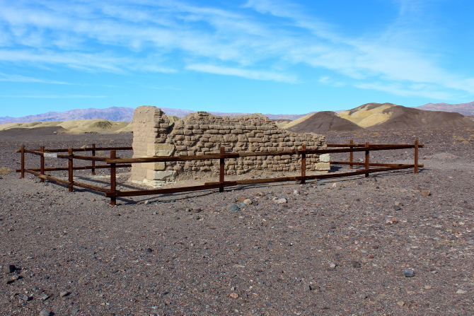
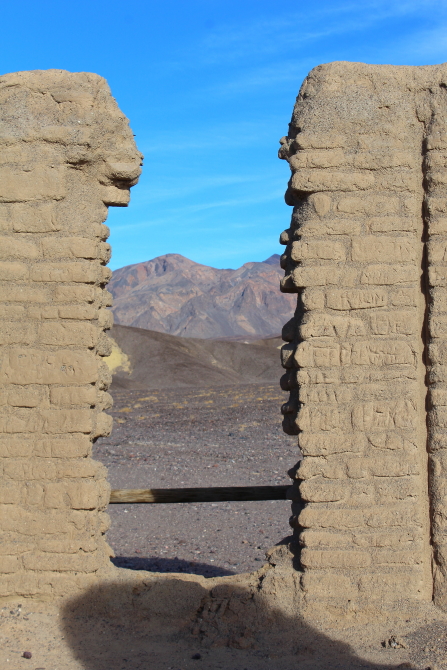
For centuries humans have use Borax (also known as sodium borate) in detergents, cleaning products, water-softening, cosmetics, anti-fungal compounds, fire retardants, metallurgy, texturing agents, insecticides, and many other uses. Located just north of the Visitor Center is the Old Harmony Borax Works display and a one-way trail that winds through Mustard Canyon. 

A Historic Market states: 
On the Marsh near this point Borax was discovered in 1881 by Aaron Winters who later sold his holdings to W.T. Coleman of San Francisco in 1882. Coleman built the Harmony Borax Works and commissioned his superintendent J.W.S. Perry to design wagons and locate a suitable route to Mojave. The work of gathering the ore (called "Cottonball") was done by Chinese workmen. From this point processed Borax was transported 165 miles by twenty mule team to the railroad until 1889. 
 

Photographer Unknown


Mustered Canyon gets its name from the mustered colored rock and dirt that is a yellow-green color. Along the trail through Mustard Canyon there are several adobe building ruins that were used when Borax was being mined at the site. It is interesting to note that the soil in this area does not support any type of plant life. 


The historic Inn at Death Valley (formerly called Furnace Creek Inn) was originally built in 1927 by the Pacific Coast Borax Company and contained twelve rooms. Over the years the Inn has been expanded and upgraded and is now open from October through May. The property is listed as a member of Historic Hotels of America. 


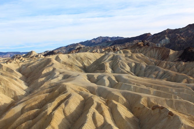
Zabriskie Point is the most photographed area in Death Valley and a favorite place to visit at sunrise and sunset. Several hiking trails leave from the parking lot and one paved trail that leads to the top of a colorful mound is handicap accessible. 


Just east of Zabriskie Point is the one-way Twenty Mule Team Canyon trail that has some spectacular scenery as it winds around and between some of picturesque formations. 


Dantes Point, at an elevation of 5,475 feet, is one of the best places to get an overall view of Death Valley National Park and there is even a paved road up the mountain. Unfortunately, the day we were there a strong northerly wind with below freezing temperatures that made us cut our visit short. Looking almost straight down from the observation point is Badwater (the lowest point in North America and the United States) and located about 85 miles to the northwest is Mount Whitney (the highest point in the continental United States). As the sun went down over the horizon, we were treated to a really spectacular sunset. 


BONUS HUMOR