Saturday, October 27, 2012

RonnieAdventure #0025 - Ward Mining District, White Pine County, Nevada

The Ward Mining District is a great place to visit if you are a history buff. Most people visit the Ward Mining District to see the charcoal ovens (Ward Charcoal Ovens State Historic Park), but the Ward town site and Ward cemetery are in the same general area and less than two miles away from the charcoal ovens on a well-maintained dirt road.  

The boom that brought people to the Ward area began in the Willow Creek Basin area when freighters discovered silver in 1872 while looking for their oxen. By 1975 Ward was the largest town in White Pine County and by 1877 Ward had a population of about 2,000 people. The town had a City Hall, Wells Fargo Office, large hotel, two newspapers, fire department, two smelters, and a stamp mill. As the town developed, an abandoned red-light district house was converted into a schoolhouse. 

When first established, Ward was a lawless mining camp; but quickly mellowed, thanks to a vigilante committee of 601 people. The Vigilante Committed believed in no trial, quick justice, and one hanging rope. After an initial purging of the town's unwanted, the Vigilantes kept the town crime-free with a crime rate of zero.

By 1878 the population of Ward began to decline as the rich ore veins were depleting and new mines were opened in the Cherry Creek Area. By 1880 the population of Ward had declined to 250 people; then on August 18, 1883, a large fire destroyed the City Hall, school, and all of the downtown buildings. By 1885 only one business remained open and the population was about 25 people. The last residents left in 1906 when the mining operations were sold to Nevada United Mines Company. Today, only a few foundations remain at the Ward town site and there are some more recent deserted mining buildings located on private property. If visiting the area, do not enter any mines as they are extremely dangerous and an accident can ruin a really great vacation.  

Rock Foundation at Ward Town Site
 
 Debris at Ward Town Site
 
 Mine Buildings on Private Land

The turnout for the historic Ward Cemetery is located on the north side of the road to Ward, and is well marked. The graves are marked with a combination of wood and stone markers and some of the grave sites are fenced.

 Ward Cemetery
 
 Ward Cemetery

The charcoal ovens that most people come to visit are listed in the National Register of Historic Places and are now part of the Nevada State Park system. The six large beehive shaped ovens are in excellent condition for their age and stand 30 feet high, 27 feet in diameter and the walls are two feet thick at the base. The ovens were built in by Italian masons (called “Carbonari) in 1876 to make charcoal from local timer in support of the smelters. Charcoal was used in the smelters because it burned much hotter than cord wood and required less space to store. Each oven held 35 cords of wood and it took 13-15 days to make about 1,750 bushels of charcoal. After the smelters closed in 1879, the stone ovens were used by ranchers to support livestock, prospectors during bad weather conditions, and stagecoach bandits as a hideout from the local law enforcement agencies.  

 Charcoal Ovens
 
Charcoal Oven Doorway


Friday, October 19, 2012

RonnieAdventure #0024 - Nevada Northern Railway & Hiwy 318, White Pine Co., Nevada

Traveling to Ely, Nevada, is always an adventure because there is nothing close to Ely. Most of the lands in White Pine County are under Federal control, so developments are far and few between. Consequently, even though it is a few more miles, many people traveling from Las Vegas to Ely will just stay on US Highway 93 all of the way. While State Route 318 is shorter, it is over 100 miles between gas stations; and then the gas stations at either end may or may not be open. Also, twice a year, Highway 318 is closed for the Sliver State Classic Challenge and the Nevada Open Road Challenge, which are 90 mile road races between Lund and Hiko.

Over the years two people have been killed during the road races, but both of the deaths were before the cars were required to have safety equipment commensurate with speed. Both of these events are now well organized with multiple classes for different driver skill levels and car speeds. (The maximum speeds are 124 MPH for Touring Class, 140 MPH for Grand Touring Class, 165 MPH for Grand Sport Class, 180 MPH for Super Sport Class and any speed for Unlimited Class.) Most of the cars are street legal and driven by people that just have a need for speed. The day before I passed through the area, a new record average speed of over 210 MPH was achieved over the 90 mile course.

Nevada State Route 318 

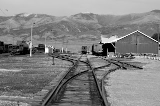
Arriving in Ely, I stopped by the Nevada Northern Railway Museum, which is America’s best preserved short-line railroad and complete rail facility still in existence. The 56-acre complex includes over 70 buildings and structures and the museum collection contains four original steam locomotives, six original diesel locomotives, and over sixty pieces of original rolling stock. The staff that operates the facility is very public-friendly and will allow you to walk around the grounds and shops, ride on the various trains, be the engineer and blow the whistle, and you can even sleep in a caboose, all for a price, of course.

The railroad facility was originally owned by Nevada Consolidated Copper Company and was transferred to Kennecott Copper Company in 1933 when Kennecott acquired Consolidated’s mining operations. When passenger service was discontinued in 1941, Kennecott converted the depot to office space until 1985, when the mine had a temporary shutdown. It was assumed that the shutdown would only last a few weeks, so everything at the facility was left in place. Then, in 1990 it was decided that the facility was never going to reopen, so the State of Nevada acquired the depot for a museum; thus, the completeness of the facility.

East Ely Depot
Rail Facilities
Rail Facilities
Loading Dock
Ore Cars
Passenger Car
Steam Locomotive
Steam Locomotive
Steam Locomotive
Steam Locomotive
Steam Locomotive
Steam Locomotive
Steam Locomotive
Diesel Locomotive
"Coming Home"
Switch Yard


Saturday, October 13, 2012

RonnieAdventures #0023 - Raintree and Mummy Springs, Spring Mountains, Clark County, Nevada

A great fall hike in the Spring Mountains is a day trip to Raintree and Mummy Springs. The most direct route is to use the Mt. Charles North Loop Trail #146 starting from Deer Creek Road (State Route 158). It is a 2.4 mile hike to Raintree and an additional 0.3 miles to Mummy Springs, one way.

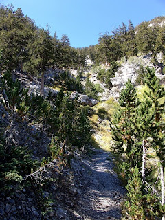
The trailhead elevation starts at about 8,400 feet and it is almost all uphill from there. During the first mile the trail meanders through the pine forest at an ever increasing grade and then a short distance later you encounter the infamous 13 switchbacks. At this point, the steepness of the grade, along with the combination of high altitude and not being in the best physical condition, will take its toll on many hikers. However, if you endure to the end, the hike is worth it. After you pass the trail summit at an elevation of about 10,000 feet, the trail descends through a beautiful Bristlecone forest until you reach Raintree.  

 One of the Thirteen Switchbacks

Raintree is located at the junction to Mummy Springs and is one of the most famous trees in southern Nevada. The tree is thought to be about 3,000 years old and is considered to be the oldest Bristlecone Pine tree in the Spring Mountain Range. However, Raintree is not considered to be exceptionally old for a Bristlecone Pine tree because Bristlecone Pine trees in other areas of Nevada and California are thought to be closer to 5,000 years old. These trees are very interesting because they are only found at high altitudes and survive in the harshest conditions. Adapting to the harsh conditions often causes the trees to become gnarled and twisted into odd shapes and sometimes only part of the tree survives. There are also many standing dead trees in the area that have numerous marks from lighting strikes.

Raintree

Bristlecone Pine Tree

Bristlecone Pine Trees
 
To find Mummy Springs, from Raintree take Trail #161 (it may not be marked) that leads downhill to the east for about 0.3 miles. You cannot miss the springs, because they are at the end of the trail. During the fall months there is very little water at the springs, but there is enough water dripping from the rocks to keep the plants green. However, in the spring months, there is enough water flowing down the ravine to create a small water fall. 

There are a number of different deciduous trees and plants in the area of Mummy Springs, which includes Aspen trees, so during the fall months there are some beautiful fall colors in the area. Later in the fall as the temperature drops, water flowing over the rocks freezes into beautiful shapes, resembling cave drapery. 

Regardless of the time of year, a hike to Raintree and Mummy Springs is always a great outing!
 
Mummy Springs

Green Plants at Mummy Springs
 
Fall Foliage at Mummy Springs


Sunday, October 7, 2012

RonnieAdventure #0022 - Mt. Charleston, Raiders of the Lost Arch, Clark Co., Nevada

Nevada is known for its lost gold mines and other treasures; so when I heard the story of the lost treasure that was buried under a large arch on Mt. Charleston, I knew it was time for another RonnieAdventure!

It all started when a friend at work told me that his ancestors were pioneers in the area and his grandfather had known an old lawyer that had a friend who was a dentist and on dentist’s death bed he told his lawyer friend the story of a lost treasure on Mt. Charleston. It seems that a number of years before the dentist died an old prospector had discovered a rich deposit of gold on Mt. Charleston that was located on the other side of a hidden passage and after filling his knapsack with gold nuggets he started for the small community of Las Vegas. However, during the trip he encountered a bad hail storm that dropped so much hail in a few minutes that the hail stones became knee deep, drifting like snow, and made walking extremely difficult. He tried to take shelter under a large arch, but the temperature was dropping so quickly that he could not keep dry and there was no possibility of starting a fire to get warm. He knew that the only way to survive was to lighten his load and get to a lower elevation. So, he buried the knapsack full of gold under the arch and had planned to come back for it at a later time. However, while descending a steep trail, it was so slippery that he lost his footing and fell from small cliff into a raging stream. After being washed downstream for about a mile he somehow managed to pull himself from the stream and then realized that he had broken both legs and his left arm as he went over a waterfall. He knew that he needed to get to Las Vegas for medical treatment, so he started to pull himself down the mountain on his stomach using his one good arm. When a rancher found him five days later he was near death, but the rancher put him in a buggy and drove him into Las Vegas where there was a local dentist that also practiced medicine. There was nothing the dentist could do for the old prospector; but before the prospector died. he told the dentist where the gold was buried. The dentist spent the rest of his life searching for the arch and the gold but could never find them. Then, before the dentist died he told his attorney friend the location of the arch as told by the prospector. Unfortunately, the lawyer was too old to go looking for the arch and treasure, so he told my friend’s grandfather the location. My friend’s grandfather was also too old, so before he died he told his son where the treasure was buried. Because the son was very wealthy, he spent most of his time on his yacht in Hawaii and was not interested in climbing mountains to look for gold. My friend said that his Father had recently been attacked by a Great White shark off of the coast of Maui, and wasn’t expected to survive, so he had decided to quit his job and go to Hawaii to look after his father's estate. After his Father passed away, he was going to take his Father’s yacht and go to Australia to live. Since he wouldn’t be around to look for the treasure, he gave me explicit directions on how to find the arch, and I agreed to cut him in for half of the proceeds when we sold the gold.    

But, the question was, who could I take along to find the treasure? Then, I remembered a professor that had just returned from searching for the Caves of Pythagoras on the island of Samos and was interested in lost treasures. I called the professor and he said that he had been traveling around the world all summer and didn’t need the money, but he would use his expertise to help find the lost arch. I knew we were ready for action when he showed up with his bullwhip, leather jacket, and felt hat.

After going over detailed maps and exploring the area from established trails, we decided on a cross-country route that would lead us directly to the arch. We had traveled less than 100 feet through the dense forest when we discovered an old trail that had washed away in many places and was heavily overgrown and being reclaimed with native vegetation. The trail was difficult to follow and traveling cross-country was very difficult because the topography was very steep and the hillsides were covered with broken rock. While trying to navigate up the broken rock slopes, we kept sliding back about one foot for every two feet we advanced. After an hour, the muscles in my legs and ankles felt like they were on fire and I was certain that I wouldn’t be able to finish the journey. However, the thought of the knapsack full of gold kept me going.

Then, through a break in the trees, I could see light through the side of large rock wall. My pulse quickened, my heart started pounding, and I suddenly had a burst of energy. As I neared the top of the hill I could see the arch plainly, but it looked small and nothing like the arch in my friend’s story. I took some pictures and decided to continue up the hill. As I crested the ridge, a beautiful arch stood before me! And, it looked like Delicate Arch in Utah! This must be the place! After removing several cubic yards of material from under the arch, we had not found the gold, but we did substantially enlarge the arch. Since it was a nice day, we decided to climb to the top of the hill and have lunch. 

After lunch we started sliding down the hill and were separated as we went around some large rocks. Then, there it was, a tunnel through the mountain that led downward at a 45° angle, and I could see light on the other side. Maybe this was a secret passage that led to some unknown part of the mountain range and the area where the old prospector discovered the gold nuggets. After lowering myself down the precarious slope of broken rock, I came out on a ledge about 100 feet above another rock slope. Since we didn’t have any technical climbing equipment with us, we decided to retreat before one of us fell and got hurt. 

On the way back to town we started talking about the gold and came to the conclusion that my friend’s father had probably found the lost knapsack full of gold; sold the gold, and then made up the story that he had made a lot of money in the stock market. Oh Well, there is always another lost gold mine to find in Nevada!
In Search of the Lost Arch

 First View of Small Arch
Small Arch
 The Lost Arch
Arch Enlargement After Material Removal Looking for Gold
Tunnel Arch Leading Downward