
The Buhl (Idaho) area is known for great trout fishing, but west of town is an amazing area of little known natural geological formations located in Salmon Falls Creek Canyon.
Balanced Rock County Park contains some really unusual rock formations. My favorite was a question mark shaped Rhyolite Monolith that is 48 feet high, 40 feet wide, and is perched on a pedestal 3 feet long and 17.5 inches wide. There is a small creek at the bottom of the canon and camping is allowed along the creek. Great place to spend a few days!


The City of Twin Falls was named for twin waterfalls on the Snake River; unfortunately, a hydroelectric plant was constructed in the area and now Twin Falls is Uno Falls. (They have not changed the name of the City.)

We were the only tourist at the Twin [Water] Falls; but Shoshone Falls, located about two miles downstream, has now become the main waterfall tourist attraction in the area. Consequently, we had to fight a crown of people just to find a parking place.


From the viewing platform at Shoshone Falls, it is possible to look downstream and see the place where Evel Knievel attempted to jump the Snake River Canyon in his steam-powered Skycycle X-2. The site is located on private property and not open to the public.

Also near the jump site is the beautiful LDS Twin Falls Temple.

However, about another two miles downstream is the Perrine Bridge, which is popular with BASE jumpers. Theoretically, a permit is required to jump from the bridge, but according to one local resident most jumpers just climb over the guardrail and make the jump.

 |
| Photographer Unknown |

We stopped by a large cheese factory in Jerome; but, unfortunately, we could not arrange for a tour of the facilities.

When we drove by the airport, there was a an old airplane parked next to the fence, but I could not get inside of the fence to take a better picture of the plane.

On our way to the Minidoka National Historic Site, I did note a Tin Man with an ax in his hand guarding some old cars by the side of the road, but he did not have much to say.

The Minidoka National Historic Site is the remains of a relocation camp where over 9,000 Japanese-Americans were held during World War II. Over 25% of all the Japanese-Americans that volunteered for active duty in the military were from the Minidoka Camp and the volunteers from this camp suffered more causalities than the groups from any of the other camps. At the entrance to Minidoda there is an "Honor Roll" that recognizes the volunteer's that were killed during their service.
The remains of the camp entry station and a few buildings are adjacent to a paved road, however, most of the sites are only accessible by walking trails.
There are a large number of swallows that make their nests under the bridge leading into the camp and it is interesting to watch them as they fly around looking for food and then return to their nests.

 |
| Photographer Unknown |


As we drove into Rupert we noticed the Minidoka County Museum, but it was not open.


Rupert has a number of really nice historic buildings and it was probably the first city in the world to have all electric streets lights. (Of course, it doesn't say how many total street lights they had!)


In the town of Minidoka there is still an old wooden water tower adjacent to the railroad tracks that was used for steam locomotives. The town also has a rather unusual looking municipal water tower.


Shoshone is the Lincoln County Seat and has a very nice veterans memorial on the front lawn of the historic courthouse. It always amazes me that some of the smallest towns have some of the nicest veterans memorials.


A few miles up the road there are a number of dormant volcanic craters and miles-and-miles of lava flow areas. Shoshone Indian Caves are located in this area and are advertised as "One of the Natural Wonders of the World," so how could we not stop for a tour.


I have been in a lot of lava tubes and after viewing the visitor center I assumed that this one would probably be a tourist trap. However, much to my surprised, it turned out to be the best lava tube that I have ever toured. Apparently, at one time the U.S. Government had considered making the lava tube into a National Monument.
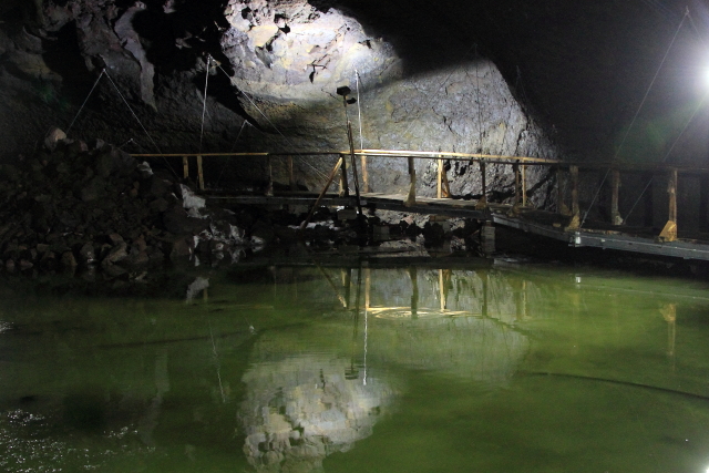
The entire lava tube is about four miles long; but due to the forces of nature, the tube has collapsed in most areas. The section of the tube covered on the tour is about 90 feet below the surface, three blocks long, 30 feet wide, and 40 feet in height.


After walking down a number of steps, the temperature drops to near freezing and there are a number of ice flows along the walls. (Our guide said that during the winter months the temperature remains below freezing and all of the water in the tube freezes solid.)


At the bottom of the tube, a boardwalk has been installed above the water level so that we could walk to the back of the tube without getting wet. (The water color is not as green as it looks in the pictures. Apparently, the camera picks up light waves differently than the human eye.)

After touring the lava tube, on the hike back to the visitor center we passed a number of different flowering plants and even a small lizard.


Located in the visitor parking lot is a statue of Washakie, the Shoshone Indian Chief that was a friend to the "Whites," even after a war against the Blackfoot Tribe. Our guide also explained that the Shoshone Indians did not have automobiles, so they trained dinosaurs to ride!

