Friday, January 31, 2014

RonnieAdventure #0085 - Presidential Libraries - Texas & California

On our recent trip to Texas, we had not intended to tour multiple presidential libraries; but as it turned out, we visited the George W. Bush, George H. Bush, and the recently renovated Lyndon B. Johnson Libraries. It always amazes me how many differences and similarities there are between each presidential library. In addition to providing information on the President, each library gives a history and an overview of what was happening in the USA during that time period. After each tour, you leave the library with a patriotic feeling and proud to be an American! (Hint: We have visited several of the libraries more than once and have discovered that to beat the crowds you should arrive early in the morning or late in the afternoon to avoid the tour buses and school kids.)

The George W. Bush Library is located on the campus of Southern Methodist University in Dallas, Texas. Part of the large exhibit includes a twisted and distorted metal support beam and other artifacts from the World Trade Center after the September 11, 2001 terrorist attack, interactive video stations that help visitors realize the process a President follows when making critical decisions, and a main gallery that is framed on four principles that are important to President and Mrs. Bush, and were stressed during his administration - Freedom, Responsibility, Opportunity, and Compassion.


The George H. Bush Library is located on the campus of Texas A&M in College Station, Texas. Included in the exhibits is an airplane similar to the one that George H. Bush was flying during World War II when he was shot down over the Pacific Ocean (He was recused two days later by a passing submarine.), the presidential limousine used during his administration, and a very informative display on the Persian Gulf War. One of President Bush's quotes displayed was "Any definition of a successful life must include service to others" and many parts of the library place emphasis on service to others.


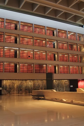
The Lyndon B. Johnson Library is located on the University of Texas campus in Austin, Texas. The recently renovated Library features new exhibits that incorporate interactive displays using the latest technology to help visitors understand the mood of the country during his presidential term. For those that are baby boomers (or older), the tour brings back many memories of the turbulent 1960s, the "crazy" clothes and hair styles, and the Vietnam War. Most sections of the library are interrelated to some part of the "The Great Society" and President Johnson's belief that "Until justice is blind to color, until education is unaware of race, until opportunity is unconcerned with the color of men's skins, emancipation will be a proclamation but not a fact." People that are old enough to remember President Johnson usually don't think of him as a humorous person, but one section of the library is dedicated to "Johnson Humor." I didn't listen to the entire program, but the one I liked was: "If one morning I walked on top of the water across the Potomac River, the headlines that afternoon would read: 'President can't swim.'"


Looking through my old files, I also found pictures from the Richard M. Nixon and Ronald Reagan Libraries, which are located in California.

The Richard M. Nixon Library is located in Yorba Linda, California, and was privately funded until 2007, when it became one of the thirteen presidential libraries now administered by the National Archives and Records Administration (NARA). Historically, presidential papers were considered to be personal property of the President, but that changed with passage of the Presidential Recordings and Materials Preservation Act. Presidential papers are now part of the National Archives. The Nixon Library is not located on a college campus; but typical of other properties in California, the flowers and fountains on the grounds are beautiful. The interior of the library contains extensive displays of President Nixon's international relations, which his administration strongly promoted, and his belief that "We must always remember that America is a great nation today not because of what government did for people, but because of what people did for themselves and for one another."


The Ronald Reagan Library is the most spectacular presidential library that we have visited, with a dynamic setting on top of a hill overlooking the Simi Valley in California. The Reagan Library is the largest of the 13 libraries administered by the NARA and contains the airplane "Air Force One" that was used by six presidents. After the plane was decommissioned, it was disassembled, completely restored to museum quality, and reassembled at the Reagan Library. Part of the Berlin Wall is also on display to remind people of President Reagan's famous quote: "Mr. Gorbachev, tear down this wall." As with most presidential libraries, part of the library tour includes a reproduction of the Oval Office. President Reagan described presidential libraries as a "classrooms of Democracy" because they are not "libraries" in the usual sense. Reagan considered the libraries to be "archives and museums, preserving the written record and physical history of our presidents, while providing special programs and exhibits that serve their communities." And, if you like presidential humor, there numerous books and tapes available in the gift shop.


Sunday, January 26, 2014

RonnieAdventure #0084 - Route 66, Kingman to Oatman, Mohave County, Arizona


Half of the driving fun when traveling to Oatman (Arizona) is following old Route 66 from Kingman (Arizona) to the Colorado River. Historically, this was one of the most intimidating parts of the “Mother Road” and in the days before power steering and disc brakes, travelers would often pay locals to drive their cars over Sitgreaves pass. Although the road is paved, it is very narrow and crooked with many hairpin turns and steep grades as it winds its way across the Black Mountains. When the road signs say “15 MPH,” they really means 15 MPH. There are numerous old vehicles that can be seen down in the ravines as you go around the sharp mountain curves.
The first stop along the way is Cool Springs, which has the slogan “Something happened here once.” The original gas station and tourist cabins were abandoned in 1966 and then in 2001 the property was sold and the new owner rebuilt the main building and reopened it in 2004. The Cool Springs sign that is now on the building is an exact replica of the vintage sign visible in old pictures and post cards. Many of the old post cards also show Thimble Mountain in the background, which is one of the most recognizable landmarks along Route 66. Since the movie Cars was released, the population of Cool Springs has been increasing and three of Mater's cousins now call Cool Springs home!


Ed’s Camp is the next historic site along the road, but the property is not open to the public. Ed, the original owner, was a prospector and then in 1917 he put up some walls with a tin roof cover (mostly from salvaged building materials) and started offering services to Route 66 travelers. He soon discovered that there was more “gold” in providing tourist services than digging in the dirt, so never did go back to prospecting. 


Shaffer Fish Bowl Springs is between Ed’s Camp and Sitgreaves Pass, but I was so busy watching the road that I missed the pull off for the springs.

When you reach the top of the hill, most people stop at Sitgreaves Pass to take pictures and enjoy the sweeping views of California, which is visible on the western side of the Colorado River. If you look closely, you can also see remnants of the Old Beale Wagon Road as it wound its way down the hill to the settlement of Goldroad.


Goldroad is now a ghost town, but you can still see numerous old building foundations and walls in the gulches, and on the hillsides, that were constructed using native stones found in the area. At one time there were 180 men that worked in the mine and Goldroad had its own post office, general store, and Freight Company. However, when the gold played out, the town was abandoned and the buildings were razed in 1949 to save taxes. In 2007 the price of gold increased and mining resumed at the site.

Oatman began as a tent camp in 1915 when gold was discovered in the area and the population grew to more than 3,500 in less than a year. In 1921 a fire burned down most of the buildings, but somehow the Oatman Hotel was saved. The Hotel is now a historical landmark and is especially famous as the honeymoon stop of Clark Gable and Carole Lombard after their wedding in Kingman (Arizona) on March 18, 1939. Clark Gable loved the town and in later years he often returned to play poker with the miners. However, as part of the Country’s war effort, the mines were closed in 1941 and did not ever reopen.
Today, Oatman has undergone a renaissance of sorts, thanks to the worldwide interest in historic Route 66. Tourist now come to Oatman to see the old mine remnants, historic buildings and “Wild West” gunfights that are held on the streets. Wild burros freely roam the town and surrounding desert lands and seem to like having their pictures taken with the tourist; especially if fed “burro chow” that is readily available from most stores in town (just be careful of where you walk). The burros are decedents of pack animals that were turned loose in the desert by prospectors and are now protected by the US Department of the Interior (DOI). 


When leaving town, the Tom Reed Mine ruins can be seen along the side of the road. 

Thursday, January 16, 2014

RonnieAdventure #0083 - Christmas Tree Pass and Grapevine Springs, Clark County, Nevada

It was late in the afternoon when arrived at the turnoff for Christmas Tree Pass, and I typically do not start a trip across the desert in the evening; but since I knew that this was a well-maintained dirt trail we decided to take a side trip to Grapevine Springs and then continue on to US Highway 95 (about 15 miles away).

Christmas Tree Pass is a beautiful scenic drive across the rugged Newberry Mountains that received its name because the local residents historically decorated Juniper Trees along the trail at Christmas time. However, the US Bureau of Land Management (BLM) frowns upon this practice and has tried to stop the tradition; but some residents ignore the warnings and still decorate trees and other desert plants at Christmas time. Since it was only a few weeks after Christmas, we were certain that some of the decorations would still be in place.

It is only about three miles from the highway to the Grapevine Canyon junction and then an additional 1/4 mile to the trailhead for Grapevine Springs. This site was listed on the National Register of Historic Places in 1984 because there are more than 250 petroglyph panels that cover rocks around the springs. It is believed that the petroglyphs were carved between AD 1100 and 1900, but no one knows for certain when they were made, what they mean, or who did the artwork. 

After leaving Grapevine Springs the mountains consist of broken surface rock that takes various shapes (some people even see animal outlines in the broken stone) and then the road climbs fairly steeply up to the Juniper Trees that are decorated at Christmas. Beyond the Juniper Trees the road has a steady downgrade for about six miles before reaching Highway 95.
 
At this time of year, the sun drops behind the mountains to the west fairly early, and it was dark by the time we reached the highway; however, we did get to see a beautiful desert sunset!