Sunday, May 27, 2012

RonnieAdventure #0004M2 - Paria Canyon, Coconino County, Arizona

Most people that want to visit a slot canyon in Southwestern United States typically go to Antelope Canyon on the Navajo Reservation near Page, Arizona. Antelope Canyon is very beautiful, and because it is so famous, it is also the most visited and photograph slot canyon in the world. This is definitely not a slot canyon to visit if you like solitude because tourist come in by the bus load and travel through the canyon on staggered tours every few minutes. Therefore, we decided to hike down Buckskin Gulch to Paria Canyon and then follow Paria Canyon to Lees Ferry, a total distance of about 47 miles (not counting side trips). The plan was to leave one vehicle at Lees Ferry and then drive the other vehicle to the Buckskin Gulch trailhead, which is located on the Arizona/Utah border. So, when we invited our new friends to accompany us on part of the trip down Buckskin Gulch, they eagerly accepted the invitation. Since our new friends only wanted to accompany us for half-a-day, they offered to drive our vehicle back to Lees Ferry; so it would be there when we finished the hike and we would not have to drive all the way back to the Buckskin Gulch trailhead just to retrieve our vehicle. This was a win-win for everyone.    

The next morning we left the motel and followed Highway 89a to the Bureau of Land Management (BLM) House Rock Valley Road #1065, and then followed Road #1065 to the Buckskin Gulch trailhead. BLM reported that the road is not maintained and a high-clearance 4-wheel drive vehicle is recommended to successfully navigate the rough, rocky and sandy parts of the road, but we found the road to in fairly good condition and we did not ever have use 4-wheel drive. (We were there in the month of May.) However, I can see where the road would be impassable when wet. 

The hike at Buckskin Gulch trailhead starts in a wide open area, but quickly narrows down to a tight slot canyon that is less than three feet wide in places. The rock is this part of the trip is red in color and the layers in the rock make for great photographs. It is also interesting to look up as you travel through the canyon because in some parts of the canyon there are logs wedged between the canyon walls 30-50 feet above the canyon floor. This is a good reminder of why you do not want to be in a slot canyon during a rain storm.

Buckskin Gulch Narrows 
  

Buckskin Gulch Narrows


        Buckskin Gulch Narrows  

Buckskin Gulch Narrows        

Arriving at the junction with the Wire Pass trail, we stopped and admired some petroglyphs that were left by early inhabitants in the area. From about 200 AD to 1200 AD, the Anasazi occupied this region and then the Paiute people arrived a short time later. Petroglyphs are found throughout the canyons, but no large village sites have ever been discovered; so researchers have concluded that the Native Americans primarily the canyon as a travel route.

Petroglyphs in Buckskin Gulch


Buckskin Gulch               


         Buckskin Gulch Narrows

Shortly after leaving the junction we discovered what we had expected, but had hoped not to find – MUD! Time to put on the water shoes! The mud soon turned to slush and then pools of some really nasty high viscosity liquid. Our friends decided to turn back after crossing through several muddy areas, so we thanked them for driving our vehicle back to Lees Ferry and wished them well on the rest of their journey. We continued on to the confluence with the Paria and a little further down the canyon we discovered a pool of nasty liquid that was about four feet deep. 

Mud in Buckskin Gulch


            Buckskin Gulch

Buckskin Gulch                 

The next morning we left our packs and hiked about a half-mile up the Paria River to Slide Arch, and then retrieved our packs and continued down the canyon. The canyon is considerably wider from this point on, but equally as beautiful. We had been warned to watch for quicksand, but we did not ever encounter any quicksand on the entire trip.

Slide Arch, Paria Canyon


Paria Canyon                

Paria Canyon

                Paria Canyon

Paria Canyon                    


             Paria Canyon

Paria Canyon

Although the total elevation change from the Buckskin Gulch trailhead to Lees Ferry is only about 2,000 feet, the hike passes through seven major geologic formations. The various layers have been exposed by erosion and encompass about 85 million years of geologic time, and each layer provides an opportunity for some really different pictures.

About midway down the canyon we dropped off our packs and made a side trip up a canyon to Wrather Arch. This is the largest arch outside of Utah, with a span of 246 feet, and reported to be one of the top five longest arches in the United States.

Wrather Arch


               Paria Canyon


Paria Canyon                                

The canyon continued to widen as we approached Lees Ferry, but the scenery was still very beautiful. The Hedgehog Cacti and many other wild flowers were in bloom, which added to the beauty of the hike. There were also more petroglyphs in this area and various ruins from early European settlers. Arriving at Lees Ferry, we felt totally exhausted, but continued to be astonished at what we had seen in the past few days. This may have to be a repeat hike!


                  Hedgehog Cactus


Petroglyphs                              


Sunday, May 20, 2012

RonnieAdventure #0004M1 - Cathedral Wash, Coconino County, Arizona

Although we did not have the opportunity to hike down Cathedral Wash to the Colorado River while we were on our Lees Ferry fishing trip, during the driving home I remembered one time that we did make the trip. We were making preparations for a hike down Paria Canyon and had stopped at Lees Ferry to leave a vehicle and decided to stay overnight at the local motel. Since it was early in the afternoon, we were looking for a local adventure and the park ranger recommended that we hike down Cathedral Wash for a little exercise before eating dinner.

We found the trailhead parking lot for Cathedral Wash to be a wide spot in the road about four miles downstream from the Lees Ferry boat dock. We were the only vehicle parked along the side of the road, so we did not anticipate meeting anyone on the hike. Looking around for the actual trailhead, we discovered that the trail actually starts on the opposite side of the road and then turns back and goes under the road through a concrete culvert. This is a nontechnical hike that is less than three miles in length (roundtrip) that can easily be made in less than two hours, so we did not take a lot of equipment. We also noticed the warning signs not to attempt the hike if it had been raining because the narrow slot canyon can be dangerous during or after a rainstorm and often there is no way to get out of the canyon in the event of a flash flood. This is always good advice when you are in canyon country.

Although this is not one of the most colorful slot canyons in the area, it was a fun hike because as you descend the canyon to the Colorado River (total elevation change of about 300 feet), you often walk on ledges along the sides of the canyon walls. And, like all slot canyons, the views of the rock formations are spectacular. We found a number of dry falls in the bottom of the wash that were easy to negotiate around and in some areas there were large rocks that required some minor scrambling, but no technical climbing gear or ropes were needed.

Walking along ledge in Cathedral Wash


Colorado River at Cathedral Wash

When we arrived at the Colorado River we were surprised to see three other people because we had seen no other vehicles in the trailhead parking lot. Shortly after we arrived, the three people left and started hiking back up the canyon. After taking some pictures we hiked back up the wash to our vehicle and headed for the motel. About a half-mile down the road we found the three people that we had seen hiking out of the canyon walking along the edge of the road toward the motel, so we asked them if they wanted a ride. Much to our surprise, we found out that one man and a woman were from Chile and one man was from Switzerland. When we asked them where there car was, they responded that they didn’t have a car – they had an airplane. The man from Switzerland explained that he was a commercial airline pilot and the woman and man from Chile were his relatives. He went on to tell us that they had flown into LAX and then rented an airplane so that they could tour part of western United States by air. They wanted to visit a slot canyon and somehow had ended up landing their airplane at the Marble Canyon airstrip and walked down to Cathedral Wash; thus, the explanation for no car. We were all staying at the same motel, so we ended up visiting with them at dinner and then decided to invite them on a RonnieAdventure as we traveled to Paria Canyon.  


Saturday, May 12, 2012

Ronnie Adventure #0004 - Lees Ferry at the Colorado River, Coconino County, Arizona

In a recent conversation that I had with Elmer, he told me that while sitting in the barber shop one day he overheard a patron telling the barber about a fishing trip he had taken to Lees Ferry on the Colorado River. According to the patron, the trout he caught were record size and he caught a fish on almost every cast. Why sometimes, the fish would jump right out of the water to grab the lure while it was still in the air before it could even hit the water. This sounded too good to be true -- time for a RonnieAdventure!

Since we didn’t want to clean too many fish, we just purchased one-day fishing licenses ($17.25) at the local store and checked into the National Park Service campground ($12 regular/ $6 Senior with a Golden Age card). There was no moon that night, so the night sky was brilliant and the Milkeyway was really spectacular. The stars were so bright that you did not even need a flashlight to walk around the campground.

The next morning we were up and at the boat launch area before it was even light. The only problem was that we forgot to bring a boat. Therefore, we decided to walk up stream from the boat launch area and fish along the way until we got too tired of pulling in fish.

 Early Morning Fishing on the Colorado River

First cast – No fish! Second cast – No fish! Tenth cast – No fish! Maybe Elmer should have asked the patron exactly where he was fishing and what lure he was using. Continuing up stream, we had the same results. 76th cast – No fish! 77th cast – No fish! Changing lures didn’t seem to help either. After walking about two miles upstream in four hours, and after 500 casts with no fish, be decided to retreat back to our vehicle that we left at the boat launch area. The walk back was pleasant because the trail winds past the Lees Ferry historic ruins and it was now light enough to take pictures. As an added bonus, the National Park Service has placed interpretive markers along the way that tell the story of tragedy, triumph, hardships and homesteading in the area.

 Remains of Fort Meeks

Lees Ferry Fort Trading Post

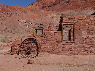
Lees Ferry Fort Buildings

Boiler Used To Power River Crossing Steam Engine

According to published information, Jacob Hamblim made the first river crossing at this site (“Pahreah Crossing”) in March 1864, but it wasn’t until the winter of 1869-1870 that a small stone building and corral were erected on the site and named “Fort Meeks.” In 1871, John D. Lee became the first permanent resident in the area; and, although there were no approach roads on either side of the river, on January 11, 1873 Lee started operating ferryboat service across the river. As more settler moved into the area, tension between the Navajos and settlers begin mounting, so in 1874 a new and larger defensive fort (“Lees Ferry Fort”) was constructed just down-river from Fort Meeks. However, regardless of what you have seen in the John Wayne movies, there never were any confrontations at Lees Ferry Fort; so the Fort was converted into a trading post and later a residence, school, and mess hall. It is one of the historic buildings still intact at Lees Ferry.

Charles H Spencer Wreckage and Main Boiler

Charles H Spencer Secondary Boiler

USGS Cabins

Also nearby are the partially submerged remains of the Charles H. Spencer steamboat and two stone cabins built by the U.S. Geological Survey. The stone cabins have been renovated, but are not open to the public. The Charles H. Spencer steamboat was built in 1911 and brought to Lees Ferry to transport coal for gold refining operations. A 110 horse-power marine boiler powered a 12 foot stern paddle and the boat averaged 5-6 tons of coal on each trip from a coal deposit located upstream from Lees Ferry. During a flood in 1921, the boat sank in shallow water and the superstructure was salvaged for its lumber. The main boiler is located in shallow water close to the shore and a second boiler is located just inland from the wreckage.
 
Colorado River Fishing

Back to Fishing! Traveling downstream from the boat launch area proved to be a better choice for fishing, producing several nice native Rainbow Trout. We continued down river for about a mile before we arrived at the confluence of the Colorado and Paria Rivers. From this point downstream the water on the west side of the Colorado River is very murky because the Paria River carries a large amount of silt during the spring months, which ruins fishing from the west side of the Colorado River in this area. We had considered hiking down Cathedral Wash to try fishing (about four miles south of the boat launch area), but decided that the water would still be too murky; so we decided that is was time to try fishing from the east side of the Colorado.

Navajo Bridges

Looking Down on River Rafters From Navajo Bridge

Fortunately, about five miles south of the boat launch area there are two bridges that cross the Colorado. The original Navajo Bridge (built in 1927-1928) is 18 feet wide, 834 feet long, 467 feet high, and has a 22.5 ton weight capacity. It has now been converted to a pedestrian bridge and is not open to vehicular traffic. While walking across the bridge I looked over the edge and noticed some river rafters far below, giving one a real sense of height from the bridge.

In 1990, trucks using the bridge were reported to be carrying loads in the 40 tons weight range (far exceeding the designed load capacity of the bridge) and traffic across the bridge had increased substantially, so plans for a new bridge were started. The new Navajo Bridge is adjacent to the original bridge, but it is 44 feet wide, 909 feet long, 470 feet high. It opened in 1994. There is an interpretive center on the west side of the bridge that is worth visiting. On the east side of the bridge, the Native Americans have various display areas where they sell Native American crafts. The turquoise jewelry work is especially beautiful and the more expensive pieces show a high degree of craftsmanship.

While I was examining the various crafts, I noticed an Elderly Native American gentlemen sitting in his pickup. I always like to visit with local people, so to start a conversation I asked him what he thought of the Navajo Bridges and all of the other great modern technological improvements that the settlers have brought into this area. He thought for a moment and then responded “When settlers found this land, the Native Americans were running it. No Taxes. No debt. Plenty of deer, elk, and other wild game for everyone. Women did most of the work. Medicine man was free. The men hunted and fished all day.” He paused for a moment and then added “Only a fool is dumb enough to think they have improved that system.” Time to head back across the bridge to find our vehicle. 
  
Downstream From the Confluence of the Peria and Colorado Rivers 

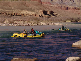
River Rafters on the Colorado River

Fishing on the east side of the river turned out to be an adventure just to find a place the get off of the mesa and down to the water. After a few hair raising four-wheel drive trails, we finally found a place that we could use to gain access the river. Views from the east side of the river were spectacular and it was interesting to see how the Paria River discolored the beautiful blue color of the Colorado. There were also a number of river rafters that came by while we were walking along the river’s edge. Fishing, however, was slow with only one fish in about an hour. Consequently, we decided to head for home. After crossing the bridge again, we stopped by an area of balanced rocks located along the Vermilion Cliffs and the famous "Rock House" (a house built around a large boulder).

Balanced Rocks Along Vermilion Cliffs

Balanced Rock (Not Our Car)

Balanced Rocks - About To Fall Over?

                                               Rock House (Built Around the Large Rock)

A little farther down the road (near milepost 557 on U.S. Highway 89A) a roadside marker and display area have been constructed to commemorate the 1776 expedition of Dominguez and Escalante as they attempted to find a safe overland route from Santa Fe to Monterey, California. This was the first party of Europeans to visit the area and the natives fled when they first saw the white people, thinking they were some type of spirit. The interpretive signs indicate that after the natives were coaxed to return, they brought pinion nuts and two roasted rabbits to share with the explorers.

Dominguez y Escalante Expedition Marker

Apparently, the party did not ever reach Monterey; however, they did established a good rapport with the natives and were able to travel the entire 1700 miles without firing a single shot or uttering a word of anger with the natives.

Stay tuned for the next RonnieAdventure!  


Sunday, May 6, 2012

RonnieAdventure #0003 - Brownstone Canyon, Red Rock Canyon National Conservation Area, Clark Co., Nevada

Okay! Time to try out my new GPS skills! Back to Red Rock Canyon NCA, but this time it is a trip to a remote canyon (Brownstone Canyon) that requires a 4-wheed drive vehicle with high ground clearance. Fortunately, I happen to have one of those. Arriving at the trail head I reset my trip computer and we are ready to go.

This area is filled with unusual rock formations and remains from Native American Inhabitants, making it great one-day trip. As we hike up the canyon we stop often to take pictures of the beautiful scenery.

"Rock Fins"

Small Arch

"Brain Rock"

When we come to the Native America petroglyphs, I set a waypoint! Hiking farther up the canyon we come to an Agave Roasting Pit used by early Native Americans. The pictographs and paintings are beautiful in this ara are in very good condition for their age, which is probably because they are protected by an overhanging rock formation. The painting are very unusual because instead of being the typical Southwest red color, these paintings use a combination of white, black, yellow and red pigments. I set another waypoint! After about another mile we come to the last man-made dam in the canyon and set another waypoint. Now I think I’ve got it!

Petroglyph

Pictograph

Rock Painting

 Arriving back home, when I plug in my GPS unit the computer screen looks worse than it did before. Apparently I didn’t follow the correct steps to clear my trip computer and delete the Colorado Waypoint. Time to head back to REI! Fortunately, I find my favorite Sales Associate and I show him the mess I have on my GPS screen. The first thing he asked me was if I had been out of State with the unit. I admitted that I had taken the GPS unit with me on a trip and put in a Waypoint so that I could find my way back to the hotel. I detected that he was having a hard time keeping a straight face when he announced: “I know what your problem is! You have never stopped making new tracks. This unit is smart enough to make new tracks even when the unit is turned off. Therefore, everywhere that you have traveled to has been recorded as a new Track.” It turns out that every time you want to stop making new tracks, you have to manually push the Track Log button and select Do Not Record in order to keep the unit from making new Tracks. Then he suggested that I take the REI GPS class.

 The first thing I learned in class was that there are some major omissions in the instruction manual and you could probably never figure out the correct way to use the GPS unit without someone to show you the key functions and correct sequence of steps that must be taken to get accurate results. The instructor was very patient, and since most of the people in the class were senior citizens (I felt pretty tech savvy because some of the people in the class didn’t know which was the top of the unit.), the instructional pace went at a very slow pace. However, it bothered me when the instructor started the class by saying that using a GPS unit was as easy as programming your new HD digital TV. I’ve never figured out how to program my HD digital TV either! We learned about declination and the UTM (Universal Transverse Mercator) grid and learned that we live in a flat, two-dimensional world, as least as far as the UTM grid system is concerned. We also found out that unless you calibrate your UPS unit at the trail head, you probably are not going to get good results. (They forgot to tell me that one in the instruction manual.) They also gave out a lot of other good information, so I would recommend that if you purchase a new hands-held GPS unit, you take the class before spending a lot of time with the instruction manual. After the class, I went home and typed up a list of instructional steps that must be followed to get the unit to work correctly and taped the instructions to the back of my GPS unit. Okay! Time to start over! So, I went into Base Camp and deleted all of the existing GPS data on my computer and the data that was stored in the GPS unit itself. Now let’s see what happens on the next Ronnie Adventure!

Here are the steps to follow if you purchase a new handheld GPS unit

At Home
·         Clear your GPS Unit Memory

At Start of Hike
·         Calibrate Compass
·         Reset Trip Computer
·         Start Tracks

At End of Hike
·         Stop Tracks

Good Luck!