Friday, October 18, 2024

Ronnie Adventure #0641 - Western Wisconsin

Chippewa County, Wisconsin, is so concerned about keeping their county clean, they even put up signs "Stop Poo." (GPS Coordinates: 44.886344 -91.388920)


In the late 1700s, Jean Baptiste Cadotte built a trading post on the banks of the Yellow River and in 1865 a village was established at the site in his name (without the "e"). The village was named "Cadott." When Cadotte died, he was buried on the banks of the Yellow River, but the spot was not marked and now it is now unknown where his grave is located. A hand carved wood statue of Cadotte is on display in Riverside Park and enclosed in a glass case to protect the wood. 

Cadott (population 1,424) is located half way between the Equator and North Pole. The 45th parallel is often called the halfway point, but it has now been established that the true halfway point is 9.9 miles north of the 45th parallel. There is a sign in Riverside Park where tourist can stand and have their picture taken "Halfway Between the Equator & North Pole."


On the way to Cornell, I passed by an accident that appeared to be a scene from a modern Keystone Cops movie. The police cruiser was stuck on a pile of rocks while the criminals applied the front brakes of their car too quickly and upended their vehicle. However, an ambulance was on the way, along with the volunteer fire department. 


Cornell (population 1,467) is located along Highway 27 where it crosses the Chippewa River.  The city was named for Ezra Cornell, one of the founders of Western Union, who was also a large land owner in the area. Upon his death, his estate became part of an endowment for Cornell University in Ithaca, New York.

Adjacent to the river is the only surviving pulpwood stacker in the United States. It was built in 1911, to stack large quantities of pulpwood logs until they could be processed in the nearby papermill. The pictures do not accurately represent the size of the stacker. This thing is enormous!  It dwarfs the nearby trees and building. I do not know what the wooden statue located at the base of the stacker represents because there was not a placard describing the art work.  


Indian Mounds Park is located along the western shore of Rice Lake, which is in the city of Rice Lake. Originally, there were over fifty mounds at this location, but the Smithsonian Institution excavated many of them in the early 1900s, and then in the 1950s other were excavated by different groups. Some mounds were also destroyed by developers, so currently there are only 12 unexcavated mounds around the lake. It is believed that the Rice Lake mounds were build in about 500 A.D. and they are some of the northernmost mounds ever discovered.  


Cumberland (population 2,170) is unique because it is known as "The Island City" and not located near an ocean. The main part of the city is located on an island in Beaver Dam Lake. 

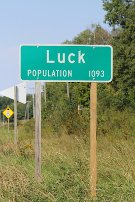
Luck (population 1,119) was originally two settlements that were close together but knew it was impractical to remain separate entities. The residents disagreed on which settlement would be the center of town, so the railroad settled the dispute when they laid their track next to the eastern settlement and the town's name became "Luck." At one time, Luck was the headquarters for the Duncan Toys Company Yo-Yo factory. 


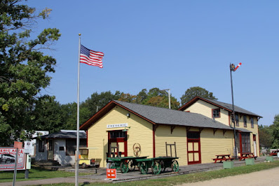
Frederic (population 1,137) is know as "The village named after a boy." In the late 1800s William Star purchased 12,00 acres of land from the Cushing Land Agency, who had purchased 50,000 acres of land from the US Government for $1.25 per acre. He persuaded the Soo Line Railroad to extend their rail line to his property and then constructed a sawmill that employed over 200 men. A town was started and soon there was a newspaper, physician, two hotel, school, and 18 retail businesses. He named the town "Frederic," after his son. 

The Frederic Area Historical Museum is now located in the historic railroad depot and there are several other historical buildings on the site. After the rails were removed, the railroad rights-of-way were converted into the Candy Dancer State Trail that is very popular with hikers, bicyclists, and snowmobilers. On a historical plaque by the depot it states: "The past should always remain a part of our future." I really like that quote. 


In the 1880s, Swedish immigrants started settling in the area that is now Siren (population 806) and by 1895 there were enough residents to apply for a post office. Since there was no postal building, the Swedes used Charles F. Segerstrom's house as the post office. Segerstrom's house was completely surrounded by lilacs, so on the postal application they listed the town's name as "Syren," which is Swedish for "lilac." The Postal Department assumed "Syren" was a misspelling and named the town "Siren." There is a nice veterans park in Siren.


Anyone driving through the northwest part of Wisconsin has probably passed through Spooner (population 2,573). Spooner is known as the "Crossroads of the North," which is a reference to the junctions of US Highways 53 and 63, and State Highways 70 and 253.  

Spooner is also known as the Hub of the "Great Omaha X" Railroad. During its heyday, passing through Spooner every day there were 18 passenger trains, 11 logging trains, 10 freight trains, 4 section crews, and 55 chain gang crews. On a reduced scale, Spooner continues to be an important railroad center.  

The Division Headquarters were located in Spooner with a large passenger depot, freight depot, express office, restaurant, switching yards, roundhouse, locomotive and car shops, lumberyards, and division office. The division office employed 600 people including the superintendent, trainmasters, dispatchers, master mechanics, road masters, bridge and building supervisors, freight agents, engineers, firemen, conductors, brakemen, switchmen, repairmen, baggagemen, and office workers. 

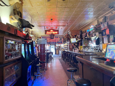
Nowadays, a popular stopping spot in Spooner is Big Dick's Buckhorn Inn. Walls in the bar are completely covered with taxidermy mounts of animals, fish and other unusual items; but the main attraction is the men's restroom. Apparently, on March 18, 1960, President John F. Kennedy was passing through Spooner and needed to use the men's restroom, so he visited Big Dick's Buckhorn Inn. There is now a plaque on the men's restroom door commemorating his visit. 

On the outskirts of Spooner there is a good guy wearing a white hat watching over things to keep peace in the community.


Friday, October 11, 2024

RonnieAdventure #0640 - Hudson, Menomonie, Elk Mound, Eau Claire, Wisconsin


In 1682, French explorers Rene-Robert Cavelier, Sieur de la Salle erected a cross near the mouth of the Mississippi River and claimed all of the Mississippi River drainage basin for King Louis XIV; thus, the lands were named "Louisiana." 

After various disputes between France and other countries, the eastern part of Louisiana was ceded to the British and the western part of Louisiana was ceded to Spain. Then, in 1803, Napoleon Bonaparte, First Consul of the French Republic, sold the remaining Territory of Louisiana to the United States for 15 million dollars, or about $0.03 per acre. This purchase doubled the size of United States.

It was unclear what President Thomas Jefferson had actually purchased because the language in the contract was very vague and did not clearly describe the land boundaries. The Louisiana Lands were generally defined as the lands between the Mississippi River and the Rocky Mountains; however, it took several years to finally define the exact boundaries. 

Over the years I have explored many places in the central and western parts of the Louisiana Purchase; but I have never spent a lot of time in Minnesota, or the lands along the Mississippi River. I had never been to the headwaters of the Mississippi River; so I decided this would be a great RonnieAdventure, but not by the most direct route. 

After flying from Las Vegas to Minneapolis/St Paul, I rented a car and drove to the Birkmose Park Indian Burial Grounds, located on a hill overlooking the St Croix River in Hudson, Wisconsin. 

There is a paved road to the top of the hill, then a hiking trail runs along the ridgeline where the burial mounds are located. Along the trail there are historic markers and benches where hikers can rest and enjoy the scenery overlooking the St. Croix River. 

It is unknown when the mounds were made, but it is believed that they date back to the Middle or Late Woodland period, which was between 100 B.C. and 1200 A.D. According to the St. Croix County Historical Society: "The Late Woodland Period was a time of cultural changes, with population growth and larger settlements. It saw the introduction of bow and arrow and maize as an important element of diet." 

According to the Archeology and Preservation Department, the mounds have never been excavated; but excavations of similar mounds have found remains of multiple individuals and a variety of artifacts in each mound. It is believed that the mounds were made by the St. Croix Valley Sioux Indians, but there are no known records that document who was buried in the mounds. 


Also located in Hudson is the Octagon House, which is now a museum that contains local historic objects including medical instruments, hand tools, cookware, tools & implements, crockery, industry & business machines and a cyclone proof house model form the 1893 World Fair. 

Devil's Punchbowl Preserve near Menomonie, has two hiking trails and a small waterfall that drops into a natural amphitheater. There are wooden stairs that lead down to the bottom of the amphitheater and another trail that leads across the top of the falls. During the spring the falls are much larger than in the fall when I visited the Preserve. 

A sign at the trailhead states that the exposed rocks in the amphitheater date back 515 million years and two uncommon ferns have been documented covering the rocks. There are also tales of ghosts, fairies, little men, and trolls that live in the Preserve. There is no charge to visit the falls, but on the web it states that visitors should bring a shiny stone or some Skittles to appease the trolls.


Mound Hill Park near Elk Mound contains an observation tower that is dedicated to deceased rural letter carriers of Dunn County, Wisconsin. It is the only such dedicated monument in America. From the top of the tower, there are great views of the surrounding area. Some documents on the web refer the tower as a "Castle," or "Dead Mailmen Haunted Castle."


Eau Claire (population 69,421) is locate at the confluence of the Chippewa and Eau Claire Rivers, and is home of the famous University of Wisconsin-Eau Claire 475 member marching bank. The band makes frequent trips around the United States and has performed at numerous locations around the world. 

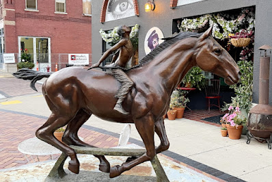
The city is known for its many arts and music festivals and located in the downtown area is the Sculpture Tour Eau Claire, which is the largest rotating sculpture tour in the nation. There are many artists that live in Eau Claire, and in August 2024, the city hosted the US Open Chainsaw Sculpture Championship. The city has also hosted the Wisconsin State Horseshoe tournament and the World Horseshoe Championship.

Eau Claire is surrounded by farms, and is known as the "Horseradish Capital of the World" because Silver Springs Foods, the world's largest grower and producer of horseradish, is located in Eau Claire. For people that like to shop at Menards, the Menards world headquarters is also located in Eau Claire.

I started my tour of artwork in Carson Park and then went to the downtown area to see Sculpture Tour Eau Claire.