Friday, December 27, 2013

RonnieAdventures #0080 - Techatticup Gold Mine, Clark County, Nevada

Driving into Nelson today you would never realize that this area was once the most lawless places in Nevada.

In about 1775 the Spaniards mined this area and called it Eldorado Canyon, but for some reason they abandoned the mines and left the area. Then, sometime about 1860 prospectors discovered the old Spanish mines with their rich veins of ore and it triggered one of the largest mining booms in the history of Nevada.

In the 1860s the nearest law enforcement was over 200 miles away in Pioche, so as more prospectors and miners moved into the area and started reopening the abandoned Spanish mines, and finding new veins of rich ore, disagreements over mining claims became prevalent and killings became routine with no one asking any questions about the deaths. Eventually, the cavalry had to be sent in to restore peace in the area. By the 1940s the mines were again abandoned and the population in the area declined significantly (2010 census lists the population of Nelson at 37).

In 1994 a canoe rental business purchased 50 acres of land in the Nelson area that included several mining claims, the company store, a stamp mill, a bunkhouse and a few tin miner cabins. They also discovered an entrance to the old Techatticup Mine that had been covered by mine tailings from the stamp mill. In its heyday, the Techatticup Mine was one of the largest and most productive mines in the area with 12 tiers of tunnels, so there were various tunnels that lead to canyon openings.

After clearing debris from the tunnel entrance,  a small part of the mine on Tier 2 was reopened for tours. Although they were not offering mine tours on the day we most recently visited Techatticup, I have included some file pictures because I have taken the mine tour several times.

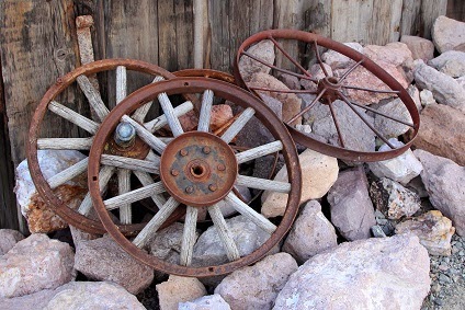
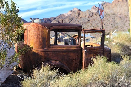
The area has also been featured in several movies, including "Breakdown," "Eye of the Beholder," "Johnny and the Highrollers," and "3,000 miles  to Graceland." The airplane that crashed in "3,000 miles to Graceland" is still located on the property, along with a lot of other historic artifacts.


Nelson's Landing is located on the Colorado River about five miles to the east, but all of the improvements were destroyed by a flash flood in 1974. After a heavy rainstorm a 40 foot high wall of water came down the canyon and washed the entire village into Lake Mohave, killing nine people.

Nelson's Landing can be reached by continuing down the paved road from the Techatticup Mine, or if you have a 4WD vehicle, you can follow the sand wash all the way to the river. There are also several side canyons that can also be followed to other locations along the Colorado River that are popular with swimmers, boaters, campers, and fisherman.


Friday, December 20, 2013

RonnieAdventure #0079 - Nelson Natural Bridge, Clark County, Nevada

A natural arch by any other name may be a natural bridge! In most parts of the world the two terms "natural arch" and "natural bridge" are erroneously used interchangeably.

According to my geologist friends, a natural "bridge" is formed by water running under a solid span, forming an opening, and an "arch" is formed by various types of erosion (wind, water, etc.) and natural forces (cracking, temperature variations, etc.) that form a hole in a solid surface. Therefore, the "Nelson Natural Arch," as known by most "old timers," is really a natural "bridge" because it was formed by water running under a slab of rock.

When the USGS has not given a geological feature a specific name, you can just create your own name; thus the "Nelson Natural Bridge" is also known as "Nelson Natural Arch," "Bridge Spring Arch," "Spring Canyon Natural Bridge," "El Dorado Canyon Natural Bridge," "Murl Emery Arch," and several other names, depending on who you ask.

Anyway, it is an easy hike of less than a mile to the "bridge" and mostly downhill. You can not miss the "bridge" because all of the drainages lead down hill to the main wash. The only problem is that when you hike back to your vehicle, it is easy to get disorganized because when looking up the hill, all of the washes look the same. However, if you watch carefully, there are a lot of rock cairns marking the trail; and if you do loose the trail, just keep walking up any wash until you reach the top of the hill and you will be able to see your vehicle.

This is a great time of year to make the hike with your kids or grandkids and there is enough water in the main wash that the kids can fall in and get wet up to their ankles!


Thursday, December 12, 2013

RonnieAdventure #0078 - Zion National Park, Part 2, Washington County, Utah

I had so much fun looking at all of my file pictures from Zion, I decided to continue the last RonnieAdventure for another week. Although most people think of Zion as park full of mountain peaks, canyons, streams and waterfalls, there are also Aspen trees in the "high country."


Pine Creek is popular for canyoneering because the trail starts at the edge of a highway and ends a few miles down the road at the same highway. The only problem with the trail is that at one point you have to rappel into a pool of cold water and then swim to the other side. However, there are some dry sections of the canyon where you can see the sun and get warmed up.


The trip to Canyon Arch is a great hike because it incorporates a number of different aspects found in Zion, all in a very short distance. The first part of the trail is well maintained and there are even steps cut in the rock to make the assent easier. The trail also goes close to Weeping Rock, which is a large alcove with dripping spring and a lot of hanging plants and moss. The trail narrows as you get higher in the canyon and there are chains attached to the canyon walls for those that would like a little extra security when crossing the narrow ledges. The arch itself is very hard to photograph, because it is in a canyon and there is no way to take a picture with nice blue sky in the background. However, it is possible to find sunflowers and blue sky in the open areas.


"Subway" is probably the most popular hike in Zion, so it is very difficult to get a hiking permit to enter the canyon. However, the wait is worth it because the scenery is fantastic,


 (Restaurant located outside of the park - If anyone knows what a "New York Style Chinese Buffet" is, please let me know. Thanks!)