From Orofino followed Grangemont Road up to Old Pierce, the place "Where Idaho First Began."

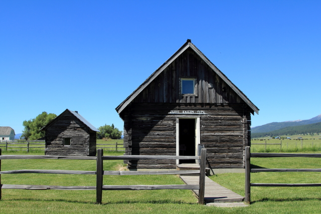
Pierce was thought to be the first town in present-day Idaho and was picked to be the Washington Territory Shoshone County seat in 1861. (At that time, Shoshone County included most of present-day Wyoming.) A courthouse was constructed in 1862 and is considered to be Idaho's oldest public building still standing. [Researchers have now concluded that Franklin (located in southeast Idaho) was settled several months earlier than Pierce, but at that time the territory had not been surveyed and everyone, including the residents, thought Franklin was located in Utah Territory.]

Although gold lured miners to the Pierce area in 1860, it was the timber industry that made many men rich. Exhibits at the J. Howard Bradbury Logging Museum include early horse logging equipment, an extensive chainsaw collection, a flag with 48 stars (the number of states when I was in school), and a really old "Snow Traveler."


The general store in Pierce is an interesting stop for anything that you may need (department store, hunting/fishing equipment, liquor store, hardware store, lumber yard, etc).They also have on display the "World's Largest Bear Trap" that is 63 inches long and weighs 138 pounds. The building also houses a large collection of trophy animals.


Two miles down the road from Pierce is the site of Oro Fino, which had "about sixty houses; nine or ten stores, more saloons than are needed, two smith-shops, two butcher shops, three families and about five hundred inhabitants." The town burned to the ground on August 10, 1867 and was never rebuilt.

In 1885 five Chinese men were charged with killing a local merchant, so the the deputy sheriff and several men were assigned to transport the prisoners to Murray for trial. However, just past the old townsite of Oro Fino a group of masked vigilantes forced the deputy sheriff to turn over the Chinese prisoners and return to Pierce. The vigilantes then hung all five of the Chinese prisoners. Today there is a footpath leading from the highway to a marker located in the forest where the hanging occurred.


Weippe is the location where Lewis and Clark made first contact with the Nez Perce on September 20, 1805. Clark recorded in his journal: "...at a distance of 1 mile from the lodges I met three boys... they ran and hid themselves... [I] search and found 2 of the boys... gave them small pieces of ribin & sent them forward to the village... a man came out to meet me, (with great caution)... & conducted me to a large spacious lodge which he told me (by signs) was the lodge of his great chief... gave us a small piece of buffalow meat, some dried salmon berries & roots... which they call Pas Seh Co (quamash)." Clark then "...collected a horse load of roots & 3 sammon" to send back to the main expedition.
The Weippe Hilltop Heritage Museum has been constructed near the place where the village was located.


The Dworshak Dam (located to the west of Orofino) is the third highest dam in the United States and the tallest straight-axis concrete gravity dam in North America. It is 717 feet high, 0.75 miles long, contains 7.5 miles of tunnels and 4.5 miles of stairways. The reservoir behind the dam is 54 miles long and has a storage capacity of 3,468,000 acre-feet of water.
In May of 1980 a 200-foot crack opened in the dam dike and 6,000 gallons of water per minuted flowed into the tunnels and entered the powerhouse. Pumps were set up to drain accumulating water in the tunnels and then a slurry mixture of concrete, volcanic ash, and other materials was pumped down the reservoir side of the dam. As the mixture was starting to set, a pump failed, so the workers began pouring slurry over the side of the dam using 5-gallon buckets. The water pressure in the reservoir forced the mixture into the crack, which significantly slowed the leak. Using grout to fill the crack from the inside, the crew further slow the leak, but they could not stop the leak completely. Engineers concluded that it would be unsafe to try any further fixes, so permanent pipes were installed in the tunnels and now drain off about 370 gallons of water per minute that still flows through the crack.


About two miles downstream from the dam, the North Fork Clearwater River joins the Clearwater river at Ahsahka. This was the site of the Nez Perce village that Lewis and Clark called Canoe Camp because they camped at this location for 11 days in 1805 and and the Nez Perce showed them how to built five canoes for their journey to the pacific.


Juliaetta (population 579) was originally named Schupferville, but in 1882 the postmaster changed the town's name to Juliaetta to honor his two daughters Julia and Etta.
Like many parts of rural Idaho, small towns are struggling to keep businesses in their downtown areas; so buildings are often reconfigured for alternate uses. In Juliaetta a garage has become a restaurant called "Bottom's Up" and the historic bank building has become "1st Bank of Pizza."


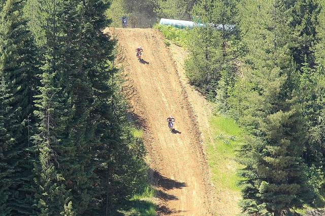
Clarkia (population 50) is a small but interesting place. It is one of only two places in the world (the other is in India) where star garnets are found. And as a bonus, Fossil Bowl is open to the public where they can dig for fossils for free.
Approaching Clarkia I had a really bad felling when I noticed that the Fossil Bowl was completely filled with RVs and motorcycles were everywhere. Stopping at the general store/gas station/bar/restaurant/hunting & fishing supply store, and other uses, the owner informed that I picked the wrong weekend to be in Clarkia because they were using the Fossil Bowl for a motocross track with a creek jump that is over an actual creek. They were also having a hill climb (called Devil's Drop).
The road to the garnet beds (8 miles away) was reported to be in poor condition, so we had a sandwich in the restaurant and enjoyed some of the races.


A few miles south of St. Maries (on the west side of Highway 3) there was a really strange looking building with a round roof. I don't think that I have ever seen a similar building.

In St. Maries I found myself in front of the Courthouse when I wasn't planning to be. Realizing that I must have taken a wrong turn, I was studying a map when a man on an ATV drove up and asked me if I was lost. I explained that I wasn't "lost," but I apparently missed Highway 3 somewhere in town. He said the intersection was confusing and I needed to backtrack two traffic lights, which I did and found Highway 3.

About seven miles out of town there was a historic marker by the side of the road explaining that the Saint Joseph Indian Mission had originally been just to the west of the sign (on the shore of Lake Coeur d'alene); but the area was a large swamp and kept flooding, so the Mission was moved to Cataldo in 1846.

Just up the road there was a Mullan Road historical marker at the junction of State Highways 3 and 97 explaining that in 1859, "Swamps in the St. Joe Valley had to be corduroyed with logs, and 70 men spent a week digging out sidehills south of here and chopping through 3 miles of forest. But after all that work, spring floods made this route impossible. Two years later, Mullan had to survey and build a new section of his road around the north of Coeur d'Alene Lake."

Just outside of Cataldo we found Old Mission State Park (aka Mission of the Sacred Heart or Cataldo Mission), which contains the original church, a parish house, and a modern visitor center. The church was constructed between 1850 and 1853 and is the oldest standing building in Idaho.


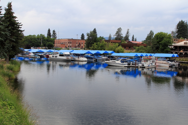
The Cedar Street Bridge in Sandpoint is the longest retail bridge in the world (It spans Sand Creek.). There are also a number of eating establishments on the bridge.


Just down Sand Creek is the marina and City Beach.

We left our trailer in Sagle and decided to take a day trip down US Highway 95. First stop was in Cocolalla at the Wolf People Store where they sell "Wolfabilia." Since they were having a sale, we were going to purchase something for Lisa; but the store was closed. The wolf viewing area was also closed. Sorry Lisa!

Next stop was the traffic signal at the intersection of Lancaster Road and US Highway 95. Although we were stopped at the intersection, the truck behind us didn't. Next stop was the Emergency Room at Kootenai Health Care Facility in Coeur d'Alene.
After spending all afternoon in the emergency room, we were released with stiff necks and sore backs. Our vehicle was still derivable, but not in any condition to pull a trailer, so we decided to leave the trailer in Sagle and drive home to recover from the accident and have our pickup repaired.
(I knew I should have left more pennies on that alley wall in Mountain Home for good luck!)