Driving to Bryce Canyon from the west, Highway 12 passed through Red Canyon. Many people enjoy Red Canyon more than Bryce Canyon because in Red Canyon you look up at the formations from the bottom and in Bryce Canyon you look down on the formation from the canyon rim. Also, Red Canyon is located in Forest Service Land, so different restrictions apply and there are NO FEES!.
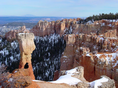
Bryce Canyon, located in Bryce Canyon National Park, despite its name, is not a canyon - it s collection of geological formations called "hoodoos' that are located in a giant natural amphitheater. The hoodoos were formed by weathering and erosion of sedimentary rock that was part of an old lake-bed (same as Red Canon).
This is a popular summer destination because the altitude at the canyon rim varies from 8,000 to 9,000 feet above sea lever. Snowshoeing and cross-country skiing are allowed in the Park during the winter months, but the trails are primarily limed to the rim area or they require special mountaineering equipment. The Winter Festival is held each year over President's Day Weekend and there are many special events to attract winter visitors. (Visit the Park Service web site if you plan a winter visit.)
We have visited Bryce Canyon several times during the summer months, but this is the only winter trip that we have ever made. (Pictures were taken several years ago.) The winter trip was enjoyable; but I still prefer the summer months because then I can hike down into the amphitheater and walk between the hoodoos.
Mossy Cave is reached from Highway 12, but it is still part of the Park. It is a beautiful hike to the cave anytime of year, but especially nice during the winter months because of the ice columns. They tell me that some years the cave ice lasts well into the summer months, but I have never found any ice in the cave when I have been there in the summer.
The trail to the cave follows an old irrigation canal that was built from 1890-1892 by pioneers using only picks and shovels. Water still flows through the canal to supply water to the communities of Tropic and Cannonville that are located downstream.
Friday, January 26, 2018
Friday, January 19, 2018
RonnieAdventure #0291 - Red Rock Canyon NCA - Bridge Mountain, Nevada
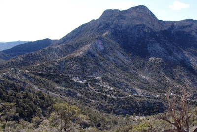
The hiking trail to Bridge Mountain starts from the summit of Rocky Gap Road (guess how it got its name) in the Spring Mountains. The Road is reached from the Scenic Drive in Red Rock Canyon NCA. Turn off of the Scenic Drive at the sign for the Willow Spring Picnic Area and then travel about 0.5 miles to the end of the pavement, which is the start of Rocky Gap Road.
To reach the Bridge Mountain Trailhead, travel the Rocky Gap Road from the Willow Spring Picnic Area to the top of the hill on a 5-mile narrow, crooked, rough, nasty, non-maintained trail called a "road." No one should attempt this outing without a high-clearance four-wheel-drive vehicle - and then there is a high probability that before you arrive home some part of your vehicle will have hit a protruding rock. The Bureau of Land Management (BLM) does not even list this hike in their hiking guide. However, with that said, this is one hike that everyone who lives in southern Nevada should put on their bucket list to do at least one time. (Pictures are from a hike we did several years ago.)
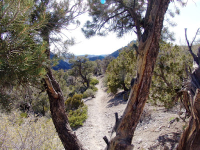
The trailhead starts near the summit of Rock Gap Road before the road descends into Lovell Canyon to the west. The first part of the trail is well marked and easy to follow as it winds through the various species of pine trees, desert shrubs, and agave plants.
But soon, the bulk of vegetation disappears and it becomes difficult to follow the trail - that is because there is no trail - just rocks to scramble over. The weather is really harsh at this altitude and due to a lack of soil, most plants can never get started or survive. Surprisingly, there are number of large tinajas along the way that contained some stagnate looking water. Then, finally, the natural bridge is reached.
Most people that have any brains quit here and go back to their vehicle; but, since it didn't look like it was too far, we decided to continue on to the top of the mountain. As it turned out, the assent was steeper than it looked and in several places there were only small cracks and rough rocks for handholds. (Due to the strong winds near the top of the mountain, the trees see the rocks for leaning post.)
From the top of the mountain it is possible to see the La Madre Mountain Range to the north, the Pine Mountains in Utah to the east, the Grand Wash Cliffs (edge of the Grand Canyon) to the southeast, and the Hualapai Mountains near Kingman (Arizona) to the South, and various California Mountains to the west.
On the way back to our vehicle it was harder going down some of the inclines than it was coming up. We did, howerver, all make it back to the vehicle and home safely!
Subscribe to:
Posts (Atom)


