 |
| Picture by Kolohe |
The Wyoming Territorial Prison State Historic Site located in Laramie (Wyoming) is one of the oldest buildings in the State (built in 1872). The Prison was known as "The Big House Across the River" and held some of the most notorious prisoners, including Butch Cassidy who was incarcerated here from 1894-1896.
Located on the 197-acre site, along with the prison, are other historic structure, a museum/gift shop, picnic areas, wetlands, and hiking trails along the Laramie River.
Diagonally across the road from the Prison is a unique sculpture that is part of the Snowy Range Rotating Sculpture Program. The large sculpture is made from Cottonwood bark, steel rods, and wire mesh.
 |
| Picture by Kolohe |
Sherman Summit (8,640 feet) east of Laramie is the highest point in the United States on Interstate-80. There is a rest area at the summit that is a popular stop because it contains a number of historic markers and monuments.
The largest monument at the rest area is a 12.5-foot-tall 4,500 pound bronze bust of Abraham Lincoln that sits atop a 30-foot-tall granite pedestal. The sculpture was originally erected in 1959 at the summit of Lincoln Highway, but was moved to the rest area when Interstate-80 was constructed.
Also relocated to the rest area was the Henry Joy ("Father of the Lincoln Highway") monument that was originally located along one of the Lincoln Highway's Continental Divides. The Joy monument was moved to the Summit Rest Area to protect it from vandalism.
 |
| Picture by Kolohe |
There is no date on the George Wyman marker, but it was probably also moved from the old Lincoln Highway to the rest area. A plaque at the Waypoint Marker states:
...After making repairs to his motorcycle at the Lovejoy Garage in Laramie, Wyman departed east along the road over Sherman Summit. While resting at the summit, he carved this inscription in the base of the flagpole, "G.A. Wyman, June 4, 1903, 11:30 a.m. - First motorcyclist to cross the Rockies, going from San Francisco to New York"...he was caught in a thunderstorm. His bike got hopelessly stuck in the mud, and a local rancher came to his rescue with a team of horses. It was late that night before he arrived in Cheyenne.
Other markers at the Summit include plaques for the Purple Heart Trail, Telephone Canyon, and Interstate construction.
One thing not moved to the Interstate-80 rest area was the large pyramid shaped Ames Monument. The monument was built in 1882 to mark the highest point (8,247 feet) on the First Transcontinental Railroad. It was reported that the pyramid is 60-feet square at the base, 60-feet high, and contains an interior passage that has now been sealed.
The town of Sherman was built around the Monument, but we could find no traces of the town site or of town's cemetery that was said to exist.
 |
| Picture by Kolohe |
A short distance east the rest area there is a tree growing out of the center of a rock located between the two Interstatde-80 lanes of traffic.
When building the railroad alignment, the tracks were moved to avoid the tree and the steam locomotives would stop when passing the tree and "give it a drink" from their water buckets. In 1901 the train tracks were moved to the south and the Lincoln Highway was constructed along the old railroad grade. When Interstate-80 replaced the Old Lincoln Highway, the Interstate lanes were separated to save the tree.
 |
| Picture by Kolohe |
The Wyoming Capitol building is located in downtown Cheyenne, surrounded by a number of statues and other State buildings. One photogenic historic State office building is located directly across the street from the Capitol.
 |
| Picture by Kolohe |
 |
| Picture by Kolohe |
Kolohe said that she cold tell we were out West when she saw "Pop" on the cooler doors in a convenience store.
 |
| Picture b Kolohe |
The Oregon Trail Ruts State Historic Site is located on the south side of the Platte River at Guernsey (Wyoming), which was a favorite stop for pioneers on the Oregon Trail because it was a one-day trek by ox-wagon from Fort Laramie. It would be possible to spend an entire day at this location and not see everything because there are a large number of historic markers, parks, and hiking trails in and around Guernsey.
The Oregon Trail, California Trail, and Mormon Pioneer Trail all passed through this same area and left deep ruts in the soft sandstone. At this location are found some of the best preserved trail ruts still visible today.
The three main encampment areas in the Guernsey area were Register Cliff, Warm Springs, and Cold Springs. We hiked part of the Oregon Trail and visited Register Cliff.
 |
| Picture by Kolohe |
 |
| Picture by Kolohe |
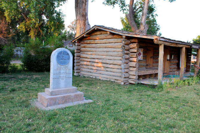
Many of the people that died on their trip West were buried in unmarked graves that were never found. However, the grave of Lucindy Rollins was found on a small hill overlooking the Platte River and it has been preserved as a memorial to all of the Pioneer Women that made the trip West.
East of the Trail Ruts there is a Pony Express Trail Marker and a monument located along the Platt River, indicting that this was the site of a Pony Express Station from 1860-1861.
At Register Cliff there is an Oregon Trail Memorial and an informational sign that tells about Register Cliff. This was one of the most prominent places along the Oregon Trail where people traveling westward carved their names in the soft rock. The earliest name ever discovered that could be authenticated was from 1797.
 |
| Picture by Kolohe |
 |
| Picture by Kolohe |
There are also a number of swallows that make Register Cliff their home.
 |
| Picture by Kolohe |
The town of Fort Laramie is located on the north side of the Platte River about three miles east of historic Fort Laramie National Historic Site, which is located on the south side of the River. In town there are two historic markers and an informational sign located on the grounds of the Fort Laramie Frontier Trading Post - one marker is dedicated to "All Pioneers that Passed This Way" and the other marker tells about the Mormon Pioneers.
The Mormon Pioneer sign explained that this was the first rest stop for Brigham Young's party after leaving Winter Quarters near Omaha, Nebraska. Fort John (later renamed Fort Laramie) and the Oregon Trail were on the south side of the Platte River, but Young's party was on the north side. Young was informed that because of the rough terrain ahead it was not possible to stay on the north side of the river going westward, so Young built the first ferry in the area to cross the Platt River. Men were left to run the ferry for future pioneers and the ferry was used for over 20 years.
The informational sign was entitled "If I Should Die Before..." and tells about the diseases and deaths that were common along the trail. There were an average of ten deaths for every mile along the trail. The top causes of death were unclean water, poor food preparation, chilly night watches, sleeping on cold or wet ground, exhaustion, and diseases - measles, whooping cough, fever, cholera, and dysentery.
 |
| Picture by Kolohe |
 |
| Picture by Kolohe |
Just west of town there was an unmaintained marker in a road ditch that stated:
The Cheyenne-Black Hills Trail passed near this point between 1876 and 1887. Built to supply the Dakota gold camps, the road was constructed in violation of the Ft. Laramie Treaty of 1868, which reserved the Black Hills for Sioux Indians. Stagecoaches and wagons carrying passengers, freight and gold bullion rumbled through nearby Ft. Laramie, an important stopping point along the line, until the arrival of the Chicago and North Western Railroad rendered the route obsolete.
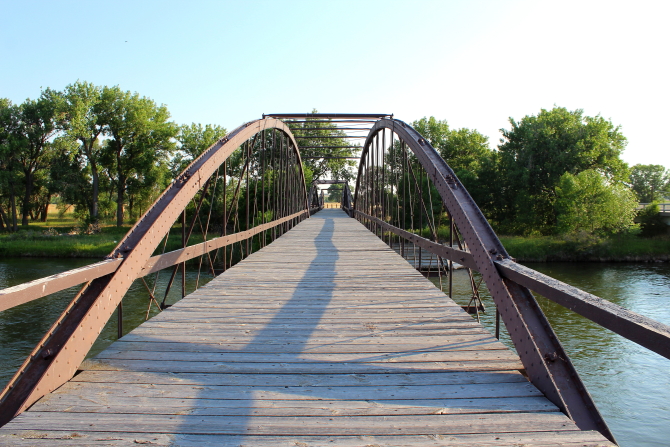
The old Platte River Army Bridge was constructed in 1875 and is closed to vehicular traffic, but people are still allowed to walk across the bridge. On the west side of the River there is a plaque that marks the place where in 1841 a trading post was built by Lancaster P. Lupton.
 |
| Picture by Kolohe |
 |
| Picture by Kolohe |
The 536-acre Fort Laramie National Historic Site contains 36 significant physical remains that include 13 standing buildings, 11 standing ruins, and several buildings where only the foundations remain. In 1890 the Fort was decommissioned and the last remaining troops were transferred to Fort Logan near Denver, Colorado.
 |
| Picture by Kolohe |
 |
| Picture by Kolohe |
 |
| Picture by Kolohe |
 |
| Picture by Kolohe |
 |
| Picture by Kolohe |
 |
| Picture by Kolohe |
 |
| Picture by Kolohe |
 |
| Picture by Kolohe |
 |
| Picture by Kolohe |
 |
| Picture by Kolohe |
 |
| Picture by Kolohe |
 |
| Picture by Kolohe |
 |
| Picture by Kolohe |
 |
| Picture by Kolohe |
 |
| Picture by Kolohe |
 |
| Picture by Kolohe |


No comments:
Post a Comment