Elmer
informed us that finding the south trailhead was a little difficult, but we didn’t
have to worry or bring a GPS unit because he had been there many times and knew
the route like the back of his hand. That should have been the first clue!
We
left early in the morning before it was too hot and after traveling for about
an hour we found an unmarked paved road leading from the main highway. However,
within a few miles, the pavement ended and the dirt road started deteriorating, but was well traveled. After
several more miles Elmer turned onto an unmaintained two-track dirt trail that started
curving to the north across the desert. As we were enjoying the desert scenery, Elmer
announced that everything looked different than the last time he made the trip, but
he remembered that a one point we needed to take a trail that went to the east.
Although there were numerous forks in the road and trails that went east, Elmer
finally decided on one trail and said that he was sure this was the way. The
trail soon deteriorated and Elmer decided it was time for 4-wheel drive. After
about a mile of bouncing around on a rocky trail that went up, down, across,
and along various sand washes and through boulder fields, Elmer decided that
maybe we were on the wrong trail. The only problem was trying to figure out how
we were going to turn the vehicle around, since there were large rocks on both sides of the
trial. We decided that the best solution was to back down the trail until we found a wide spot or a place between two rocks that was wide enough for a vehicle. With people on both sides of the vehicle Elmer was able to negotiate back down the trail until we found
a place between two large rocks that we were able to wiggle the vehicle back-and-forth
between and eventually got turned around before we added any
new dents to Elmer's pride and joy. (The nice thing about Elmer’s vehicle is that it has
so many dents people don’t even know when he adds a new one.)
Arriving
back at the fork in the road where we made the wrong turn, we decided to go
north until we came to another fork in the trail, which fortunately for Elmer
turned out to be the correct trail. We knew that we had found the trialhead when we came to a cable that was stretched
across the road. This is the boundary of the North
McCullough Wilderness Area and there was a small clearing where Elmer could turn
the vehicle around so that Martha could start the trip back to the north side
of the canyon. After getting the vehicle turned around, the group wanted to
have a short snack before they started the hike; but, being a little impatient,
I told Elmer that I was going to start hiking and I would just meet everyone at
the saddle that I could see on the horizon.
From
the wilderness boundary, the trail (Trail #300) immediately starts up a small
unnamed dry wash and I had not gone too far when I came to a fork in the trail
that Elmer had forgotten to tell me about. Both trails looked equally used, so
I decided to go to the left. The trail soon disappeared and I turned to boulder
hopping and scrambling though brush, but I knew that I was going in the right
direction because I could see Two Sisters and the saddle to the northeast.
Eventually, I did reconnect with the main trail and arrived at the saddle with
time to take pictures and enjoy the scenery in solitude until the rest of the
party arrived.
Wilderness Boundary - Two Sisters in background
After
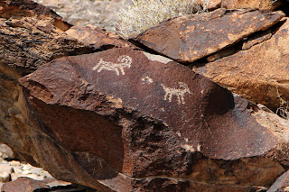
regrouping, we hiked a few miles (all downhill) until we came to Petroglyph
Gallery, which is often referred to as the “Sistine Chapel of Native American
Rock Art.” We met an archaeologist at the Gallery that had hiked in from the
north side and he gave us a tour of the Gallery and explained that the Gallery
contained over 300 rock art panels with over 1,700 documented individual designs
that had been created by what is believed to be native cultures from the Puebloans
(Archaic Period) to historic eras after Europeans visited the area (one
petroglyph appears to show a European on a horse). We were told that some of the designs may be
7,000 years old. Circular and rectilinear lines are the most common motifs in
the Gallery, but there are also numerous anthropomorphs (human-like) and zoomorphs
(animal-like) figures. This site is sacred to many Native Americans, so we were
careful not to disturb anything. In addition to the rock art, there are also signs
of Early American hunting blinds and milling operations in the canyon that are
of interest.
From the Gallery we had about a two mile hike to the vehicle. Part of the group went on the new trail (Trail #200), which bypasses the Class 3rock climb on the north side of the Gallery, and the rest of the group continued down the canyon to the junction with Trail #100, and then on to the waiting vehicle. The ride out from the north side of the canon is along a rock covered trail that requires a high-clearance vehicle to go five miles in about an hour, but everyone arrived home safely and reminisced about the great time that we had.


No comments:
Post a Comment