
When traveling on Interstate 40, the drive from Nashville to Memphis takes about three hours. However, it is really difficult to find a RonnieAdventrue when traveling on the Interstate. So, we drove a slightly different route that took a little longer, like four times longer.
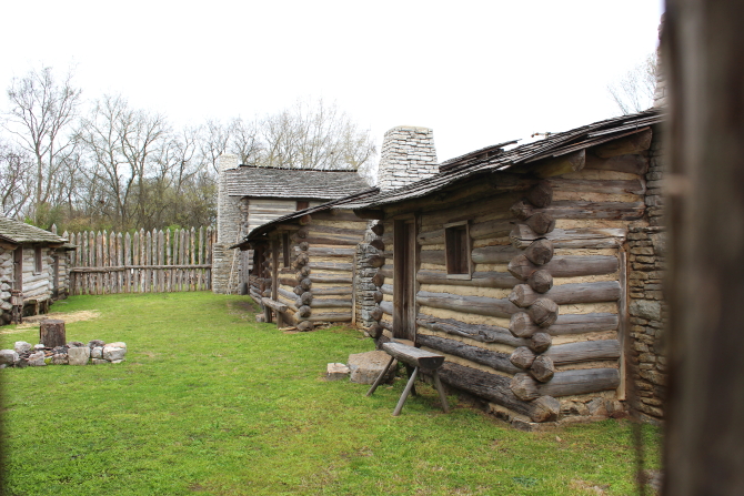
In 1772 Kasper Mansker and others settled in the area just north of Nashville that is now part of Goodlettsville (population 16,798). Fearing Indian attacks, in 1779 a log fort was built on the west bank of Mansker Creek, but the fort turned out to be too small and inadequate for the growing number of people moving to the area. The fort was abandoned in 1780 and the settlers moved away. The original site is now part of a retail parking lot that contains a historic marker.

In 1783 Kasper Mansker returned to the area and this time he built a stronger stockade on the east bank of the creek. The fort was never attacked by Indians
A replica of the historic 1779 fort has been built on the east side site and is now part of the Goodlettsville Visitor's Center. Tours are available by people in period clothing at certain times of the day. The original 1787 Bowen House is also located on the site. It is the oldest brick house in middle Tennessee.
 |
| Picture by Kolohe |

 |
| Picture by Kolohe |
 |
| Picture by Kolohe |
 |
| Picture by Kolohe |

The Robertson County Courthouse in Springfield (population 17,277) was constructed in 1879 and is surrounded by a number of historic buildings that are still occupied. There are placards on the buildings that give a historical account of what the buildings were used for over the years since construction.
On top of the Courthouse is a cupola with a clock that has faces in all four directions. There are also two different veteran memorials located on the Courthouse front lawn.
 |
| Picture by Kolohe |


While we were taking pictures, we noticed a number of people with small children walking around Courthouse Square, stopping at various stations along the way. Kolohe went over and asked one of the teenage girls what was going on and she explained that the families stopped at each station and a high school student at that station read them a page from the popular children's book "The Rainbow Fish." At the end of the tour, each child received a bag full of goodies and the family received a copy of the book. Kolohe thought this was a great idea to get families involved in reading.
 |
| Picture by Kolohe |
 |
| Picture by Kolohe |
 |
| Picture by Kolohe |

The town of Adams (population 671) has an interesting historical park that features a number of buildings, including the original Bell log cabin. Quilt patterns painted on buildings were popular on this part of the trip.
 |
| Picture by Kolohe |


Port Royal (population 0) was founded in 1797 and soon became an economic hub for the tobacco market. Tobacco was inspected and then moved down river on flatboats that were also constructed in Port Royal. As settlers moved west, the town served as a resupply point on the Great Western Road, which at that time was the only direct route into Missouri and the West.
In 1859 a Masonic Lodge & General Store was constructed and now serves as the visitor center for Port Royal State Park. Hampton's Lodge No. 137 occupied the second floor of the building and the ground floor was occupied by a dry goods store. However, when the railroad bypassed Port Royal, the town went from a major commerce center to a ghost town.
A covered-bridge abutment and the Masonic Lodge & General Store are the only original structures left standing in Port Royal. For safety reasons, the remaining parts of a covered bridge were demolished a few years ago. In addition to the highway bridge, there is also a foot-bridge that crosses the river.
Kolohe said that she will never forget Port Royal. As we were getting ready to leave, she realized that she had lost her cellphone while taking pictures. I told her to just listen and I would call her phone. Then she explained that it would not do any good to call the phone because she had turned off the ringer. We did not think that we would be able to find the phone in the tall grass and weeds, but decided to search the area anyway. Miraculously, within 10 minutes we found the phone. For the rest of the trip she left the phone ringer turned on.


 |
| Picture by Kolohe |


Fort Defiance Civil War Park & Interpretive Center is located in Clarksville (population 166,722). On February 1, 1862, the Union Navy moved upstream to take the fort, but were surprised when they arrived and found the fort deserted and flying a white flag. Union troops occupied the Fort for the rest of the war and it became a safe haven for local freedmen, many of whom joined the U.S. Colored Troops. Fort Defiance was originally known as Fort Sevier, but the name was changed when Union troops occupied the site.
 |
| Picture by Kolohe |

 |
| Picture by Kolohe |


Clarksville was founded in 1785 and is the only incorporated municipality in Montgomery County. The City is named for General George Rogers Clark, brother of William Clark of the Lewis and Clark Expedition.
Montgomery County has had really bad luck with courthouses. The first five were destroyed by wind and fire and the current sixth courthouse was hit by a tornado five years after being completed, ravaged by fire a few years later, and then damaged by a tornado again in 1999. Some citizens wanted the sixth courthouse demolished, but a judge refused and ordered the damage be repaired. The Montgomery County Courthouse is now a beautiful refurbished brick building located in the Public Square.
The Leaf-Chronicle, a Clarksville daily newspaper, is the oldest newspaper in the State of Tennessee. It was first published in 1808. The "Leaf" refers to tobacco leaf, the area's predominant agricultural crop. In 1995 the newspaper became part of the Gannett Newspaper Division.
 |
| Picture by Kolohe |
 |
| Picture by Kolohe |


Diagonally across the street from the Courthouse is the historic Customs House Museum & Cultural Center, Tennessee's second largest general interest museum. The building was constructed in 1898 for use as a post office and custom house to handle the large volume of foreign mail created by the international tobacco industry. The building's designer included many different architectural styles, including: Stick, Queen Anne, Italianate, Romanesque, Flemish, and Gothic.
 |
| Picture by Kolohe |

No comments:
Post a Comment