Historically, Bridgeport (Nebraska) was known as "Trail City USA" because it was located along many western trails, including: Oregon, California, Mormon, Pony Express and Sidney-Black Hills Trails. Consequently, there are numerous monuments and historic markers in and around Bridgeport.
At Bridgeport most of the trails were located on the south side of the Platte River. The Mormon Trail, however, was still on the north side of the River and did not join the other trails until it reached Fort Laramie. At Fort Laramie Brigham Young had to cross over to the south side of the Platte River because scouts informed him that the terrain on the north side of the river was not passable with wagons.
 |
| Mormon Trail camp site on north side of Platte River |
 |
| Oregon Trail Marker on south side of Platte River |
 |
| Sidney-Black Hills Trail Marker - south side of Platte River |
Chimney Rock was one of the main trail markers along the south side of the River because it could be seen from a great distance away. Although this is a National Historic Site, the property and the visitor center are maintained by the State of Nebraska. There is a hiking trail that runs from the visitor's center out to the formation, but we decided to save that hike for a different trip. (Sophia was amazed at how large the grasshoppers were in Nebraska.)
 |
| Picture by Kolohe |
 |
| Picture by Kolohe |
Along with Chimney Rock, Courthouse and Jail Rocks were also used as trail markers. These three rock formations are the most famous and recognized landmarks along the westward trails. Unlike Chimney Rock that requires a hike to reach the formation, there is a dirt road that leads up to the east side of Courthouse and Jail Rocks. It is easy to find the dirt road because there is a stone marker located at the turnoff that leads to the rock formations.
 |
| Picture by Kolohe |
 |
| Picture by Kolohe |
 |
| Picture by Kolohe |
 |
| Picture by Kolohe |
 |
| Picture by Kolohe |
There is also a paved road on the south side of Courthouse and Jail Rocks that provides a different perspective of the formations when looking to the north.
 |
| Picture by Kolohe |
Harrisburg (population 100) was the home base for the stagecoach and mail carrier lines in 1892. At that time there were two hotels, two livery stables, a brickwork, a cheese factory, two banks and three newspapers. Today, Harrisburg is a near ghost town.
The Double L Café is located along the highway that bypasses Harrisburg and is such a popular stop that they have parking meters in front of the building. There was even a sweet little old lady giving out treats when we walked into the restaurant.
 |
| Picture by Kolohe |
 |
| Picture by Kolohe |
 |
| Picture by Kolohe |
 |
| Picture by Kolohe |
 |
| Picture by Kolohe |
Kimball (population 2,496) was originally called Antelopeville because of the large number of Antelope found in the area. However; when the railroad reached Antelopeville, they changed the name of the town to Kimball to honor one of the railroad officials.
Historically, Kimball declared itself to be "The High Point of Nebraska," with an elevation of 4,715 feet. However, that distinction has now been given to Harrison, which has an elevation of 4,876 feet.
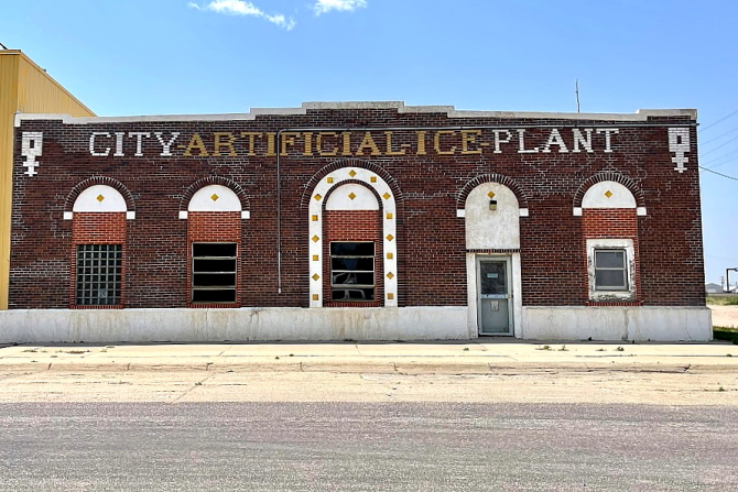
As we were driving through Kimball we noticed a "City Artificial Ice Plant" in the downtown area. We are still trying to figure out what "artificial ice" is and what it is used for. No explanation was provided on the City's web site.
 |
| Picture by Kolohe |
 |
| Picture by Kolohe |
Located just west of Kimball are the remains of an irrigation system that was constructed in the early 1900s. The patented Galvanized Steel Flume was develop and manufactured in Kimball by Patrick Maginnis. The Maginnis Irrigation System was used extensively throughout the region.
 |
| Picture by Kolohe |
 |
| Picture by Kolohe |
A large statue of the Virgin Mary ("Our Lady of Peace") is located adjacent to Interstate 80 near Pine Bluffs (population 1,129). According to GPS coordinates, the statue is actually located a few feet on the Wyoming side of the State Line. The statue was reported to be made of marble dust from a quarry near Wheatland, Wyoming, and then mixed with a sealant to bond the dust particles together.
Also located in the same area as the statue is a marker for the "Old Texas Trail" that was used from 1866 to 1897 to drive cattle from Texas to Wyoming.
 |
| Picture by Kolohe |
 |
| Picture by Kolohe |
Gas was less than $1 per gallon in Pine Bluff, but the filling station was closed. Everywhere we went on this trip, and when we found a filling station with gas prices posted for less than $1 per gallon, the station was closed.
 |
| Picture by Kolohe |
 |
| Picture by Kolohe |
On our way to Denver our GPS unit told us that there were traffic problems on the Interstate ahead in Wyoming and we needed to get off of the Interstate and take back roads into Colorado. While traveling the backroads we stopped in Briggsdale for gas, but someone had stolen the gas pumps. Fortunately, there was another gas station in town.
 |
| Picture by Kolohe |


No comments:
Post a Comment