 |
| Cart Creek Bridge, Flaming Gorge - Picture by Kolohe |
The first known exploration float trip down the Green River through Flaming Gorge was in 1825 by William H. Ashley, organizer of a large fur trading company that he established in the area. Then, in 1869 John Wesley Powell floated down the Green River through Flaming Gorge and continued his float trip down the Colorado River through the Grand Canyon. It was Powell that named Flaming Gorge after he saw the sun reflecting off of the red rock canyon walls and thought it looked like flames. In later years, Butch Cassidy and the Wild Bunch frequently hid in the Canyon and the surrounding area.
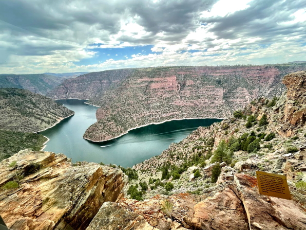
Construction of the Flaming Gorge dam started in 1958 and the dam was completed in 1964. In 1968 the Flaming Gorge National Recreation Area (NRA) was established and placed under administration of the U.S. Forest Service as part of Ashley National Forest.
When filled, the reservoir quickly became an attraction for boaters and most famous for its fishing. Because of the reservoir's cold, clear depths, conditions are ideal for growing enormous trout. The world record Mackinaw lake trout of 51 pounds 8 ounces was caught in the reservoir and other large trout have been caught including German brown trout over 30 pounds and Rainbow trout over 25 pounds. Also caught in the lake are Cutthroat trout, Kokanee salmon, and Smallmouth bass. Water exiting the dam is about 55-degrees Fahrenheit, so excellent trout fishing is also found below the dam.
The arched concrete dam stands 502 feet high and the reservoir backs up 91 miles to the north. When full, the reservoir elevation is 6,040 feet above sea level.


 |
| Picture by Kolohe |


 |
| Picture by Kolohe |
 |
| Picture by Kolohe |

The Sheep Creek Geologic Loop Scenic Drive is located just south of Manila, Utah, on the west side of Flaming Gorge Reservoir. This is a beautiful drive that should not be missed by anyone traveling through the region.

 |
| Picture by Kolohe |
 |
| Picture by Kolohe |

John Wesley Powell started his famous 1869 float trip through the Grand Canyon from Expedition Island on the Green River in Green River, Wyoming. The island is now a beautiful park with a large number of monuments and informational signs describing the area's history.
 |
| Picture by Kolohe |
 |
| Picture by Kolohe |


While in the City of Green River (Wyoming) we also wanted to visit the Greater Green River Intergalactic Space Port, but we could not locate it because people keep stealing the sign and the Space Port location does not show up on any earthly maps. I did, however, find some Space Port information on Wikipedia that stated:
On July 5, 1994 Resolution R94-23 of the Green River City Council designated this landing field as the "Greater Green River Intergalactic Spaceport" for inhabitants of Jupiter who might wish to take sanctuary in Green River in the event their planet is threatened by collisions from comets or meteors, in apparent reference to the contemporary Comet Shoemaker-Levy 9 impact.
 |
| Web Picture - Photographer Unknown |
Each year the City hosts an International Day Celebration at Bunning Park in the historic downtown section of Green River. We just happened to be in Green River that day, so we attended the festival and stayed for dinner in the evening. Kolohe also found a pickup that she wanted to purchase because it looked a lot like her SUV, but they would not sell it to her. (I can not disclose the source, but after seeing the pickup picture someone said that it would be an upgrade compared to what she is currently driving.)
Bunning Park is part of the Rock Springs historic district and contains numerous memorials and historic markers. Currently many of the original buildings in the historic district are being renovated and repurposed. There is also a large herd of cattle found throughout the City that have been decorated by various individuals, businesses, and organizations.

 |
| Picture by Kolohe |


 |
| Picture by Kolohe |
 |
| Picture by Kolohe |

 |
| Picture by Kolohe |

 |
| Picture by Kolohe |


The population of Point of Rocks, Wyoming, is listed as three (3) on Wikipedia and the population does not appear to have changed much since the last census. But, Point of Rocks is still three times larger than Buford that has a population of 1.
Located on the south side of the railroad tracks is the historic Almond Stage Station that is still standing and considering that it was build in 1862, it is still in very good condition for its age. Also on the site are what appear to be the remains of a barn and corral.
A sign in front of the Stage Station listed Wells Fargo's Stagecoach Etiquette:
- Abstinence from liquor is requested, but, if you must drink, share the bottle. To do otherwise makes you appear selfish and unneighborly.
- Buffalo robes are provided for your comfort in colder weather. Hogging robes will not be tolerated and the offender will be made to ride with the driver.
- Don't snore loudly while sleeping or use your fellow passenger's shoulder for a pillow; he or she may not understand and friction may result.
- In the event of runaway horses, remain calm. Leaping from the coach in panic will leave you injured, at the mercy of the elements, hostile Indians and hungry coyotes.
- Gents guilty of unchivalrous behavior toward lady passengers will be put off the stage. It's a long walk back; a word to the wise is sufficient.


 |
| Picture by Kolohe |
 |
| Picture by Kolohe |
 |
| Picture by Kolohe |
 |
| Picture by Kolohe |

While we were in the area, a curious antelope stopped by to see what we were doing.

Wamsutter is located along the Old Lincoln Highway in the Great Divide Basin between two Continental Divides. The community was described in a 1941 travel guide as:
On summer nights, this lonely place is merely a small group of lights set in blackness and silence. Over the immense darkness, stars shine brilliantly, neither dimmed by other lights nor hidden by smoke and dust in the air. A meteor flames against the winking stars; an aeroplane, winging toward Cheyenne or Salt Lake City, seems trying to imitate it. Wamsutter is on the edge of the Red Desert, where colors change hourly, according to the brilliance and direction of the sunlight.
An informational sign in a Wamsutter park stated:
Ute and Shoshoni Indians once roamed this semiarid desert but were eventually forced out after the 1850s by increasing numbers of whites traveling along a transcontinental corridor containing the Overland Trail. Stage stations served as the first settlements until 1868 when the Transcontinental Railroad was built. Wamsutter emerged as a section town on the mainline of the Union Pacific, and later developed as a railhead for shipping cattle and sheep with stockgrowers from Wyoming and Colorado using the stock yards.
 |
| Picture by Kolohe |

After leaving Green River we drove on Interstate-80 that mostly followed the Old Lincoln Highway. In some places the Old Highway is unimproved and in other places it is used as an Interstate access road. In still other locations the Old Lincoln Highway is designated as Highway 30 and varies several miles either north of south of the Interstate. Since Interstate-80 bypasses many small towns, we followed the Old Lincoln Highway when possible.
Lincoln Highway was the first designated transcontinental highway for automobiles across the United States and had a total length of 3,389 miles. The idea of a transcontinental highway was conceived in 1912 by Henry Joy and it was dedicated October 31, 1913. The highway ran from Times Square, New York, to Lincoln Park in San Francisco. After a realignment, the highway passed through 14 states, 128 counties and more than 700 towns and cities.
Henry Joy was the president of the Packard Motor Car Company and always said that Lincoln Highway was "The greatest thing I ever did." Joy told his family that when he died he wanted to be buried along the Lincoln Highway at one of the Continental Divides where he saw the most beautiful sunset that he had ever witnessed.
Joy died in 1936 and his family elected to have him buried at home, but they did build a monument for him along the Lincoln Highway at the place where he had wanted to be buried. In order to protect the monument from increased vandalism, the monument was moved to the Interstate-80 Summit Rest Area east of Laramie in 2001 and replaced with a wooden marker.
Along with the Henry Joy wooden marker, there is another wooden market that explains there are two Continental Divides in this area, which is a result of the Great Divide Basin.
In the Wyoming Wind River Range near South Pass, the Continental Divide loops, creating the Great Divide Basin. The Old Lincoln Highway, and current Interstate-80, pass through the southern end of the Basin. On the east side of the Basin water drains to the Atlantic Ocean and on the west side of the Basin water drains to the Pacific Ocean. However, water that falls into the Basin drains inward and cannot escape except through evaporation. Therefore, each side of the Basin is considered to be a Continental Divide.

very nice Ron! Jeff Larson Phoenix love your stuff!!!
ReplyDelete