 |
| Panoramic Picture by Kolohe (Taken From Kraft Trailhead Looking Northwest) |
There is also an out-and-back trail that goes northwest to Ash Springs, which is located at the base of the westernmost mountain.
Although not shown on the Red Rock Canyon NCA maps, a loop around the center mountain is delineated on one of the AllTrails maps. Therefore, we decided to follow the Kraft Trail Loop to Gateway Canyon and then go counterclockwise around the middle mountain for a great RonnieAdventure!
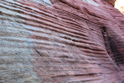
The hike to the saddle between the two mountains is steeper than it appears in the pictures, so we stopped several times for rest breaks and to take pictures of the unusual rock formations along the trail. (As I get older, some of the trails seem steeper than I remember them from the last time I hiked the trail.)
The below picture was taken from the saddle between the two mountains, looking back at the trailhead.
From the saddle, looking toward Gateway Canyon, Turtle Head Peak is visible in the background.
Hiking down to Gateway Canyon there were more unusual rock formations along the way.
Walking in Gateway Canyon was fairly easy at first and we even encountered some snow in the shady areas.
However, when we came to the junction where we had to continue our counterclockwise loop, we found a lot of brush and rock in the canyon. After climbing over some rocks and winding our way around and through the brush, we eventually arrived at the saddle between the two most western mountains sporting a few unexpected cuts and scratches
 |
| Picture by Kolohe |
 |
| Mojave Yucca (Yucca schidigera) |
 |
| Nevada Agave (Agave utahensis) |
 |
| Barrel Cactus (Ferocactus acanthodes) |
The view from the saddle was great, unfortunately, there was no trail leading down the canyon. That is when we realized it was going to require a lot of rock scrambling to get back to the trailhead.
On our way down the canyon we encountered a number of Class III drops, but noting that required ropes or climbing gear.
 |
| Picture by Kolohe |
 |
| Picture by Kolohe |
Looking back up the canyon that we had just descended. The rest of the hike back to the trailhead was mostly level terrain
 |


No comments:
Post a Comment