Mexican Hat (population 31) is located adjacent to the San Juan River in southeast Utah on the northern edge of the Navajo Nation. The name "Mexican Hat" comes from a near-by sombrero-shaped balanced rock that measures 60-by-12 feet.


A short distance to the north on highway U.S. 163 is Valley of the Gods scenic loop. The rock formations in this area are very similar to many formations in Monument Valley. However, this area is managed by the US Bureau of Land Management (BLM), so there are no entrance fees.
The 17-mile dirt loop trail that winds around the formations is passable in a passenger vehicle during dry weather, but a high-clearance four-wheel-drive vehicle is recommended because of the sand and rocks.

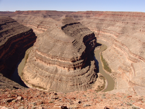
The Gooseneck Overlook is in this same area and provides a nice view of the San Juan River as it winds its way through the deep canyons. One of my "Bucket List" items is to float down the San Juan.
Natural Bridges National Monument contains a number of natural bridges, one of which is the thirteenth largest natural bridge in the world. There are also a number of Indian ruins in the canyons.
"Natural bridges" are different than "arches" because bridges are formed by water erosion flowing under a rock layer to form a "bridge.".Therefore, "bridges" typically span a canyon, while "arches" are formed by wind and weather erosion and can occur anywhere.
In 1904, the National Geographic Magazine publicized pictures of the bridges that were seen by President Theodore Roosevelt. He was so impressed with the pictures in 1908 President Roosevelt created Natural Bridges National Monument, which was Utah's first National Monument. Because there were no roads in the area, and access to the monument was only by horseback, very few people visited the monument until the 1950s when dirt roads were constructed in the area for mining purposes. Utah State Route 95 that leads to the bridges was not paved until 1976.
Due to its remote location, the Monument has the only National Park Service night sky monitoring station in the United States. The night sky rates a Class 2 on the Bortle Dark-Sky scale.


Mule Canyon Ruins (GPS Coordinates: 37 32 21.50, -109 44 31.12) are located on BLM Land and are reached from Utah State Route 95 about 20 miles southwest of Blanding. (Ruins are not listed on most maps.)
Close to the highway there is a nice interpretive site that includes a kiva and other ruins. From the parking lot there is a hiking trail to the canyon's rim and various cliff dwellings are visible across the canyon. However, to visit Flaming House Ruins (House of Fire) requires hiking up the canyon from a trail that starts from Arch Canyon Road to the east of Mule Canyon Ruins. Unfortunately, we did not have time to make the hike; but I have seen many beautiful pictures of the ruins.


No comments:
Post a Comment