During the winter months, trees were cut and the logs held in the dams until spring when the ice melted and the logs could be moved to the mills. A historic marker on the side of the highway indicated that in 1904 the water was treacherous and only half of the logs made it to the mills. Four lumberjacks lost their lives during that log drive.

There is a historical marker in Cascade indicating that in 1878 (about a mile north of the sign) four men were ambushed by Indians while trying to recover stolen horses. Three of the men were killed immediately; but "Three Finger" Smith, "being a man of experience in such maters," fled southward and found the cavalry. Smith estimated that they were ambushed by at least 75 Indians; but when the cavalry arrived at the site, the Army trackers determined that there had only been 5 Indians (and the Indians were never caught).
 |
| This is what happens when you have wrong camera settings |


At the entrance to the campground where we were staying in McCall, there was on old Army aircraft parked by the side of the road. The wings had been removed and were on the ground in front of the aircraft. It was unclear why it was parked there. Maybe someone was going to restore it.

One evening it was still light after dinner, so we followed a backroad around Payette Lake (about 20 miles). This was a beautiful drive and the road ran next to the lake in most places.


New Meadows is located at the junction of Highways US 95 and State Route 55 and considers itself to be "The Center of Idaho Heart Land."
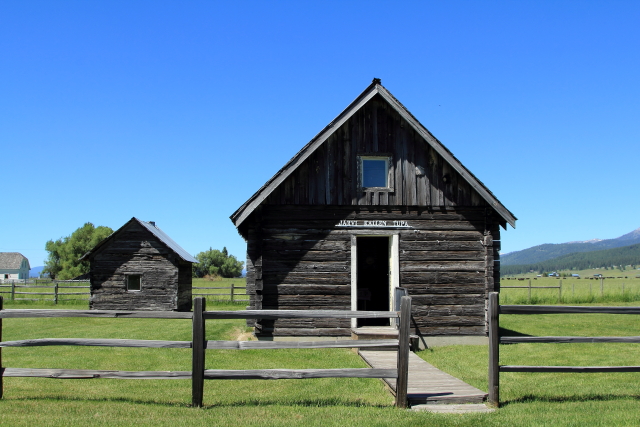
Parker John's Cabin is located just north of New Meadows and is a famous Idaho historic Landmark. A roadside marker states: "Territorial political conventions (Republican in 1863 and Democratic in 1864) used this facility as a point where North Idaho leaders could meet with southern representatives to choose congressional candidates." The site is now a state park with a campground located along a small stream.


A few miles north of the junction we crossed the 45th Parallel. (A point halfway between the Equator and the North Pole.)

The one bad thing about pulling a trailer is that you can not always stop or turnaround when you want to take a picture. Just before we entered Riggins was one of those times.
Riggins is a small town not close to anything and when I came over a hill on the outskirts of town, I thought I was in downtown Los Angeles. There were cars, pickups, campers, and people everywhere. After driving through the small community I found a place to pull over and I walked back to a gas station to find out what was happening - Salmon fishing season! But what was so strange is that all of the fishermen were crowded into one small section of the Salmon River and no one was fishing on the other side of town where I parked.


After leaving Riggins on US Highway 95 there were signs of historic hydraulic mining on the west bank of the river. A historical marker by the side of the highway stated that Hydraulic mining "shot powerful streams of water against a pre-historic river bed (now the bank of the stream) to expose and wash down gold-bearing gravel, which then was sluiced to recover the gold." Unfortunately, it left ugly scars on the landscape!

US Highway 95 runs through the Salmon River Canyon that was carved about 15 million years ago when the mountains were rising and the river eroded into the older rock below. This is a beautiful drive because the road follows the river through the canyon. Unfortunately there were not a lot of stopping places when you are pulling a trailer and the existing pullouts were typically on the wrong side of the road.


The road up White Bird Grade was one of the more difficult grades that I have done since Alaska. I had to downshift to second gear and go about 35 mph just to keep the transmission temperature from going into the red zone. Anyway, near the top of the grade there is a turnout and observation area for the White Bird Battlefield (Nez Perce National Historical Park).
This battle was the start of the Nez Perce War when over 100 cavalrymen charged a band of about 60 Indians down a ravine in order to stop them from crossing the river. The Indians wiped out a third of the cavalry, forcing them to retreat, and no Indians were killed during the battle.


Grangeville is the largest city, and the county seat, in Idaho County. This is a popular tourist destination and we have camped in Grangevill before at a beautiful campground just outside of town.
People like to vacation in the Grangevill area because this is where the Camas Prairie meet the Nez Perce National Forest, Grangeville is the Nez Perce name Sike-sike, meaning "the foot of the mountain."


Traveling north on Idaho State Highway 13 the road parallels the Clearwater River and passes through the community of Harpster (now just a few scattered houses and buldings). However, during the mining boom Harpster had a hotel, livery barn, harness shop, four saloons, two general stores, drug store, and a blacksmith shop.

Kooskia is located up the road from Harpster at the confluence of the South and Middle forks of the Clearwater River, which was the location of the Chief Looking Glass Village and his band of Nez Perce. The Nez Perce word koos-koos-kia refers to the Clearwater River, "the lesser of the two large rivers in the vicinity, the other being the Snake."
During WW II the Kooskia Internment Camp was located about 30 miles northeast of town and was so remote that fences and guard towers were unnecessary. Apparently, there is nothing left at the Internment Camp site.


Just south of modern day Kamiah is the location of the 1806 Lewis and Clark Long Camp where the Corps of Discovery waited six weeks for the snow to melt from the high ridges of the Lolo Trail. [It is now possible to follow the Lolo Trail over the Bitterroot Mountains from the Weippe Prairie (Idaho) to the Bitterroot Valley (Montana) along a single-lane dirt trail without services - a high-clearance 4WD vehicle is recommended.]

Orofino is located on the east side of the Clearwater River at the junction of Highways US 12 and Michigan Avenue (Grangemont Road) and has a really nice campground that runs along the east side of the river. There are flowers, metal sculptures, and there is a nice old grain elevator is just downstream from the bridge!


No comments:
Post a Comment