
Just down the road the highway goes over the Big Bend Dam dike, which is another one of the large rolled-earth dams across the Missouri River. Just before crossing the spillway there is a nice memorial that states: "In Memory of the Dakota whose lives were taken at Fort Thompson in 1863. These were the innocent exiled from Minnesota, who suffered hardship and sickness at this camp. The stone that stands here, reminds us of the land from which you came. May we all walk with the Great Spirit in Prayer."

After crossing the dam dike, we drove along the east side of the river to see if we could find any Fort Thompson ruins, but all we found was a recreation area and a few wild turkeys. (We were later told that the only thing left of Fort Thompson is the old church, and it is located about 40 miles south of the dam.)


Continuing our journey southward we came to the South Dakota Hall of Fame in Chamberlain; but we decided to save our tour of the Hall of Fame for another visit.


The Lewis and Clark Interpretive Center in Chamberlain (located at the Interstate 90 Exit 264 rest stop) overlooks the Missouri River and contains a recreation of the expedition's 55-foot keelboat. We missed the dedication of the new 50-foot tall Sacajawea statue (named Dignity) by a few days, but we did tour the center and view the exhibits.
The 12-ton stainless steel Sacajawea statue was made by artist Dale Lamphere and is a gift to all of the people of South Dakota.
Lamphere said that Sacajawea's face is not based on a single person, but he used three different models that were 14, 29, and 55-years of age.
The star quilt behind Dignity is very meaningful in the Lakota and Dakota cultures. The Lakota/Dakota tradition is that "When a baby is born, they are wrapped in a star quilt because they came down from the stars so to speak."
If you stay around until it gets dark, Dignity is illuminated by a series of LED lights.
Lamphere's next project is to built the "Arc of Dreams" that will span the Big Sioux River in downtown Sioux Falls.


 |
| File Picture |


Just across the River in Oacoma is Al's Oasis, which is famous for their homemade pies!


White Lake is about halfway between Chamberlain and Mitchell and was made famous on November 11, 1935 when the National Geographic Society/U.S. Army Air Corps jointly sponsored balloon ascension set a World's Altitude Record of 72,000 feet, and then landed safely near White Lake. Located at the northwest corner of Main and Division Streets is a park that has a number of beautiful markers and monuments, in addition to the National Geographic Plaque.

For those people that grew up in South Dakota, you probably remember that whenever you were misbehaving your Mother would threaten to send you to Plankinton Reform School for Children. Well I have good and bad news. First, the good news - Plankinton Reform School for Children no longer exists. Now the bad news - the facility is still there but it is now called Aurora Plains Academy.

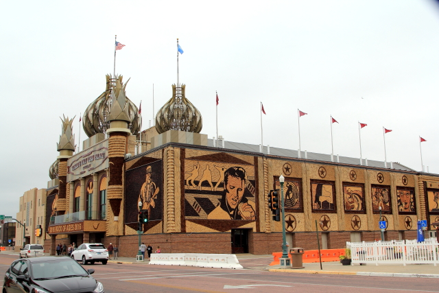
No trip through Mitchell would be complete without stopping at the "World's Only Corn Palace." Each year the exterior of the building is decorated with pictures made from South Dakota corn and grasses. The 2016 year's theme is "Rock of Ages."


The Mitchell Prehistoric Indian Village located just north of town has been described by the U.S. Department of the Interior as "one of the most important archaeological sites in the Northern Plains." This is the only archaeological site in South Dakota that is open to the public.
Archaeologist have learned that the site was a major bison processing center where bison were processed (butchered) on an industrial scale for the manufacture of pemmican. The people were also skilled farmers that grew corn, beans, squash, sunflowers, tobacco and amaranth.


We were told that just north of Tripp there was an Amish community that sold handcrafted items, so we decided to take a detour from Interstate 90 to see if we could find the community. Unfortunately, we drove around several farming communities and ended up finding Delmont, but no Amish community.
In Delmont we discovered the "Onion House" that was constructed in 1902 and was named for the onion shaped dome that was part of the house. There were also several other historic buildings in Delmont.

Just outside of Milltown we drove past the old mill that is located adjacent to the James River, but did not have time to stop because we were late for a dinner appointment. My niece and her family live in Alexandria and had invited us to their house for a fish-fry.

Alexandria is easily recognizable because of its grain elevator and historic-looking water tower. We had a great dinner of Walleye Pike that my niece's husband caught in the Missouri river, then we had to head for home.


Before leaving South Dakota we drove through Mission, which is where Bob Barker (host of The Price is Right for a number of years), spent most of his youth. Bob is part Sioux Indian and is listed as an official member of the Sioux Tribe.

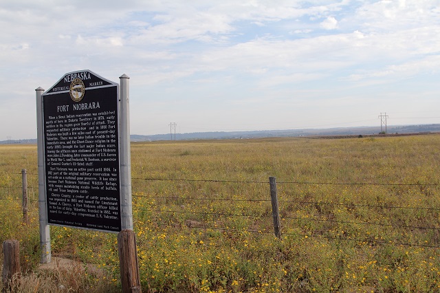
Fort Niobrara was constructed in 1880 (a few miles from present-day Valentine, Nebraska) to protect early settlers in the area. There were never any Indian problems in this area; but John J. Pershing, later commander of U.S. forces in World War I, was stationed here along with Frederick W. Benteen, a survivor of General Custer's staff.
In 1906 the Fort was decommissioned and in 1912 part of the original military reservation was set aside as a national game preserve. The area is now known as the Fort Niobrara National Wildlife Refuge, which maintains large herds of buffalo, elk, and Texas Longhorn Cattle.
The Bryan Bridge is the only arched cantilever truss bridge of its kind in the United States. The bridge was built in 1932 and the two sides of the bridge are connected in the center with only a single pin.
The bridge is 289 feet long, 24 feet wide, and was designed by an immigrant from Russia that graduated from the University of Nebraska in 1929.
In 1932 the American Institute of Steel Construction selected the Bryan Bridge as the "Most Beautiful Steel Bridge of 1932" and the Bryan Bridge was the first bridge between Wisconsin and the Pacific Coast to receive such an award.
The bridge is still open to vehicle traffic, so I drove across the bridge and I am happy to say that the one pin holding the bridge together did not break.


The Sandhills, one of America's most unique physiographic features, are located in Western Nebraska and cover about one-fourth of the state. A Nebraska Historical Marker indicates that "The sandy soil acts like a giant sponge, soaking up rain and forming a vast underground reservoir. Hundreds of permanent lakes are found here. However, the same sandy soil makes the area unsuitable for cultivation. Grasses flourish, making the Sandhills ideal cattle country." The Sandhills are the largest and most intricate wetland ecosystem in the United States!

No comments:
Post a Comment