
By waiting until September (2006) to do a five day hike in the Bridger Wilderness Area in southwest Wyoming, we did not have to worry about black flies, mosquitoes, or other hikers.
We arrived at Mud Lake in the late afternoon, so we decided to start our hike at the Big Sandy Trailhead early the next morning.
I always have the most energy the first day of the hike; so we made good time, arriving at Big Sandy Lake about noon. After having lunch, we decided to continue our journey and cross the Continental Divide at Jackass Pass. After about the first mile, it became obvious why they call this Jackass Pass - not a lot of fun with a 40 pound pack.
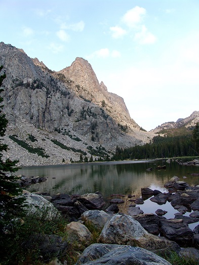
After crossing Jackass Pass, we stopped at Lonesome Lake to take pictures of Pingora and Cirque of the Towers (rock formations) and then continued on to Lizard Head Meadow where we camped the first night. I wanted to watch the sun come up over the mountains in the morning, so I pitched my tent right in the middle of the meadow - bad choice of camping spots. That night it got down to about 10 degrees Fahrenheit and I didn't put a water bottle in my sleeping bag. The next morning, all my water bottles were frozen solid! Now I realized why there were no black flies, mosquitoes or other campers! It is pretty sad when you have to thaw your water bottle over the camp stove in the morning. For the rest of the trip, I kept a water bottle in my sleeping bag at night.


The second day we followed the North Fork of the Popo Agie River eastward toward Pinto Pass then up the Ice Lakes Trail to the high country. The third day was down the Middle Fork of the Popo Agie River and then up the Sweeetwater Gap. My hiking companion informed me that "The Sweetwater River flows out of the Winds and heads east; the emigrant trail followed the Sweeetwater between the Platte River and South Pass over the Continental Divide." I can not even imagine how difficult it must have been for the emigrants to pull handcarts over this route!


It rained off-and-on all day, so we really wanted to get across the Continental Divide before dark. However, when we arrived at Crique Lake my mind was willing to continue on, but my body said it could not go any farther; so we decided to call it a day. Crique Lake is at an altitude of about 10,800 feet and we were somewhat worried that the rain would turn to snow and we may not be able to find the trail in the morning.


As it turns out, it did not snow that night; but it did rain fairly hard. My tent leaked and everything got wet! Fortunately, the sun came out the next morning and we made it over the Contentinal Divide at Temple Pass, where we found some other backpackers that were following the Continental Divide southward.
We were going westward on a trail that was not in real great condition and the trail was so steep in places that pack animals were not allowed on the trail. After negotiating the steepest part of the trail, it was all downhill with breath-taking views all the way back to Big Sandy Lake and then on to our vehicle!


No comments:
Post a Comment