Friday, June 29, 2012

RonnieAdventure #0009 - "Lobo" Mine, Nye County, Nevada

As I hacked my way through the dense underbrush the sharp thorns pulled at my clothes, scratching my arms and legs; so, I was certainly glad that I had purchased a machete at the local Army Surplus Store before setting out on this adventure. (After having undertaken considerable research work at the library, I was certain that I had found clues that would lead me to the Lost Dutchman Gold Mine in the Superstition Mountains outside of Phoenix.) When I reached the end of the box canyon that I was following, all that I could see was a pile of rubble. However, near the top of the rubble I noticed a small hole that was partially covered with brush and the hole appeared to extend into the mountain. Upon closer examination, I could see an old wood beam with Spanish markings that looked like part of a mine opening. Eureka! This must be the mine entrance that I was looking for. After crawling through the small hole I found myself in a narrow tunnel leading over a deep, bottomless pit. Someone had left an old plank across the pit and it seemed safe, so I started inching my way across the plank with one outstretched hand on each wall. When I was almost to the far side of the pit, I touched something sharp with my hand, causing me to drop my flashlight. For several seconds I could hear the flashlight hitting the sides of the bottomless pit as the light quickly faded away. It suddenly became dark. Very Dark! Then it happened! I heard a loud screeching sound and suddenly I felt a blow to my shin! Then another blow to my shin! Followed by a sharp blow to my solar plexus! I opened one eye and I could see a red eye starring back at me. I knew this must be the end and I was about to be devoured by some prehistoric dragon that would eat me alive, or maybe a million vampire bats that would that would suck all of the blood out of my body. I frantically moved my hand up the wall and I could feel hair. Human hair! This was just like the Indiana Jones movie when Indy finds an old mine tunnel full of human skeletons. Suddenly, there was a booming voice that said: “Quit pulling my hair and shut the alarm off.” My hand frantically grouped for the alarm clock with the red numbers flashing “5:30.” Finding the off switch, I silencing the wretched red-eyed screeching beast with the flick of a finger! When I finally managed to open both eyes, I announced to my wife that I hated getting up in the mornings and that I was going to call the office, quit my job, and become a full time travel-adventure writer. She said that before I quit my job, she had one question that she wanted me to answer – How was I going to live on $5.00 a week? I decided to take a shower and go to work.

I had been at work only a short time when I received a telephone call from my friend Basil, telling me that he had found a book (He has also been looking for the Lost Dutchman Mine.) that gave directions to the “lost Lobo Mine” in the Spring Mountains. According to Basil, some of the old buildings and parts of the ore cart tracks at the "Lobo" Mine were still intact and worth visiting. I knew that this must be some type of omen, since I just had a dream about an old lost mine. Basil said this would be a great family adventure and suggested that on Saturday we take our families and two vehicles on an outing to find the mine. I liked the idea of two vehicles because I've been stranded in the desert before with two flat tires. When you have two vehicles traveling together, and something would happen to one of the vehicles, the other vehicle can be used to get back to civilization. We agreed to meet at 7:00 AM on Saturday.
 When I arrived home after work, I searched the internet but could find no reference to a “Lobo Mine,” or any other mine in Basil’s described Spring Mountain location. Time for a RonnieAdventure!

Saturday morning I was up early, read the paper, and was having breakfast when the telephone rang. It was Basil, telling me that he wasn’t feeling well and he had to cancel out on the trip. Bummer! I had really been looking forward to the trip. After talking it over with my wife and daughter, we decided to find the mine on our own, using Basil’s directions.

About an hour out of town, we arrived at the described turnoff and I started looking for the GPS unit, only to realize that I had left the GPS unit at home. Oh well, who needs a GPS unit when you have a paper map!

After traveling a short distance, it became obvious that we were not on the right trail. Back to the highway and after a few more paved miles we found another turnoff that looked better on the map. The only problem was that there were numerous trails crisscrossing the desert that were not shown on the paper map! While driving and simultaneously reading the map, I found myself going in circles and ending up where I started. Finally, my daughter said that she could do a better job of navigation and asked for the map. Now you have to realize that this is the girl that couldn’t find her way around the block when she was in Junior High School, but has somehow developed excellent map reading skills in later years. Within a short time she found the correct trail and we headed for the “lost mine.” Unfortujately, the trail soon disintegrated and turned out to be very rocky and rutted, so travel toward the mine was at a very slow pace.

After about an hour we had almost reached the mine when I heard a bang, then a flop, flop. Getting out of the vehicle, it was just what I had expected – a rear flat tire. Great! Where was Basil when I needed a second vehicle and some help! I was hopeful that I had a spare tire because in the three years that I owned the vehicle I had never had a flat tire. Crawling under the vehicle I located the spare tire behind the rear bumper and it was even inflated. Good, so far! Now the trick was to figure out how to find the jack/tire wrench; and, of course, there was no owner’s manual in the glove compartment. Removing the rear cargo mat I found a plastic cover that could removed without any tools and under the cover was a jack and various other tools that looked like they could be used to change a tire. The only problem was that there were no directions on how to get the tire out from under the vehicle. After about 10 minutes, I finally located a small space between the license plate and the bumper that appeared to be large enough to fit part of the jack handle through and sure enough, I was able to use the tool with the long handle to crank down the tire so that I could get the tire out from under the vehicle. The rest of the tire change went well. 

After I finished changing the tire, we walked the short distance to the old mine operation. It wasn’t quite like Basil had described, but it was still interesting. After taking some pictures, we headed back to the highway and arrived back at home without any further incidents. Now to have a chat with Basil!

Miner's Cabin

View of cabin from storage shed

Relaxing on the front porch

Mine Entrance

Ore cart tracks to tailings dump

Joshua Tree

Friday, June 22, 2012

RonnieAdventure #0008 - Tucson Botanical Gardens, Tucson, Arizona

A trip to the Tucson Botanical Gardens Butterfly/Greenhouse exhibit is always a treat when visiting Tucson. This is the only live tropical butterfly exhibit open to the public in Arizona. Although Butterfly Magic is closed during the summer months, the greenhouse exhibit is open all year and exhibits include tropical blooming plants, orchids, hibiscus, bromeliads, etc. How could you ask for a better RonnieAdventure!


The Tucson Botanical Gardens are relatively small in comparison to many other botanical gardens around the country, but Reader’s Digest voted it America’s Best Secret Garden. The site contains seventeen specialty gardens representing a variety of gardening traditions and botanical themes.


Saturday, June 16, 2012

RonnieAdventure #0007 - Mission San Xavier del Bac, Pima County, Arizona

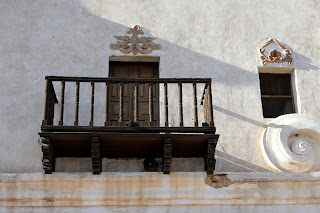
When my sister-in-law arranged for a personal tour of Mission San Xavier del Bac by one of the Franciscan Friars, I immediately gratefully accepted the invitation. The Mission is located about ten miles south of Tucson on the Tohono O’odham San Xavier Indian Reservation (formerly known as Papago) and is a popular tourist destination. The mission is also known as “the place where the water appears” because there were once natural springs in the area, and it is also often referred to as “The White Dove of the Desert” because of the structure’s exterior white color. I have visited the mission many times as a tourist, but never as a guest; so I knew that this tour would be a very special RonnieAdventure.

The Mission was originally established in 1692 by Jesuit missionary Eusebio Francisco Kino, who was the founder of 24 missions in what is now Southwestern United States and Sonora Mexico. However, in 1767 Charles III of Spain banned all Jesuits from Spanish lands in the Americas because of his distrust for them, and replaced them with the Franciscans. The original mission building that was constructed by the Jesuits was located about two miles away from the current site, but was destroyed by Apache Indian attacks in about 1770.

Franciscan Fathers Juan Bautista Velderrain and Juan Bautista Llorenz oversaw construction of the current building between 1783 and 1797, using native labor and a loan of 7,000 Pecos from the Catholic Church. In 1828 the Mexican government banned all Spanish priests from Mexican territories, so the building sat vacant until 1853 when the property was brought under U.S. jurisdiction by the Gadsen Purchase. The church was reopened in 1859 by the Santa Fe Diocese, and Franciscan priest were reassigned to the Mission.

The exterior of the building is coated with white limestone slurry from materials mined in the area and entrance into the church is through a doorway that has massive, carved mesquite wood doors. Because of the thickness of the adobe walls, the building feels cool even during the summer months. The interior of the building is richly decorated with ornamentation showing a mixture of New Spain and Native American art work consisting of paintings, carvings, frescoes, and statues that were probably created by Native American artisans. Over the years there have been several renovations projects to restore the building to its grandeur, but some of the restoration projects actually caused the building to deteriorate. The concrete stucco added in the 1980s was found to trap water inside of the building, causing damage to the interior decorations; so the concrete stucco is being replaced with the traditional mud plaster (which includes pulp from the Prickly Pear Cactus) that “breathes” and allows excess water to escape.  

When viewing the building from the front, the first thing that one notices is that the bell tower on the right appears to be unfinished. No one knows for certain why the bell tower was left uncompleted, but the two most prevalent legends are that early taxation laws did not apply to buildings under construction, so the building was never completed; and the other legend is that the second tower was left unfinished until the “Excellent Builder” will come to direct its completion.


After touring the building, a trip is not complete until one partakes of the various foods offered by Native American vendors located in the Mission parking lots. I have actually been known to drive out of my way just to stop for Fry Bread!


Saturday, June 9, 2012

RonnieAdventure #0006 - Keyhole Canyon, Clark County, Nevada

Keyhole Canyon is well known for the numerous petroglyphs that line both sides of the canyon and is popular with families that want a nice day trip that is not too far from Las Vegas. A vehicle with high ground clearance and four-wheel drive is recommended, but I have been to this site many times and four-wheel drive was never required to negotiate the two-track dirt trail from the highway to the trailhead.

Most people that visit the site typically marvel at the large numbers of petroglyphs at the canyon entrance and then stroll up a box canyon until the trial ends at a dry waterfall, returning by the same trail. Various people had told me that it is possible to hike up the north side of the mountain and then rappel down a series of dry waterfalls, where the last drop is the dry waterfall at the end of the box canyon. Although many people talk about this canyoneering trip, I had never visited with anyone that had actually made the decent. So, when a friend called and said that he found someone that had made the trip and was willing to take us through the canyon from top to bottom, I knew it was time for a RonnieAdventure!

The really bad thing about canyoneering is that either at the beginning or end of the trip you typically have to make a nasty hike to the top of the canyon. When rappelling through Keyhole Canyon, the hike comes at the beginning of the trip.


By the time we reached the top of the canyon we were feeling our age and we were glad that the second part of the trip was all downhill. As with all canyoneering trips that I have ever been on, the scenery down through the canyon was very beautiful and the photographs taken do not portray the real beauty of the canyon.


After finishing the rappels and arriving back at the canyon entrance, we spent some time admiring the petroglyphs before making our journey home. Fortunately, the weather was not too hot during the trip, but this definitely is not a summer outing. 


Sunday, June 3, 2012

RonnieAdventure #0005 - Sloan Canyon National Conservation Area, Clark Co., Nevada

Although I have hiked in Sloan Canyon  many times, I have always entered from the north side and then returned by the same trail because it a long drive around the canyon to the south side and requires the use of two vehicles in order to do a hike completely through the canyon. So, when Elmer told me that Martha would drop us off at the south side of the canyon and then pick us up at the north side, I was ready for a RonnieAdventure!

Elmer informed us that finding the south trailhead was a little difficult, but we didn’t have to worry or bring a GPS unit because he had been there many times and knew the route like the back of his hand. That should have been the first clue!  

We left early in the morning before it was too hot and after traveling for about an hour we found an unmarked paved road leading from the main highway. However, within a few miles, the pavement ended and the dirt road started deteriorating, but was well traveled. After several more miles Elmer turned onto an unmaintained two-track dirt trail that started curving to the north across the desert. As we were enjoying the desert scenery, Elmer announced that everything looked different than the last time he made the trip, but he remembered that a one point we needed to take a trail that went to the east. Although there were numerous forks in the road and trails that went east, Elmer finally decided on one trail and said that he was sure this was the way. The trail soon deteriorated and Elmer decided it was time for 4-wheel drive. After about a mile of bouncing around on a rocky trail that went up, down, across, and along various sand washes and through boulder fields, Elmer decided that maybe we were on the wrong trail. The only problem was trying to figure out how we were going to turn the vehicle around, since there were large rocks on both sides of the trial. We decided that the best solution was to back down the trail until we found a wide spot or a place between two rocks that was wide enough for a vehicle. With people on both sides of the vehicle Elmer was able to negotiate back down the trail until we found a place between two large rocks that we were able to wiggle the vehicle back-and-forth between and eventually got turned around before we added any new dents to Elmer's pride and joy. (The nice thing about Elmer’s vehicle is that it has so many dents people don’t even know when he adds a new one.)

Arriving back at the fork in the road where we made the wrong turn, we decided to go north until we came to another fork in the trail, which fortunately for Elmer turned out to be the correct trail. We knew that we had found the trialhead when we came to a cable that was stretched across the road. This is the boundary of the North McCullough Wilderness Area and there was a small clearing where Elmer could turn the vehicle around so that Martha could start the trip back to the north side of the canyon. After getting the vehicle turned around, the group wanted to have a short snack before they started the hike; but, being a little impatient, I told Elmer that I was going to start hiking and I would just meet everyone at the saddle that I could see on the horizon.

From the wilderness boundary, the trail (Trail #300) immediately starts up a small unnamed dry wash and I had not gone too far when I came to a fork in the trail that Elmer had forgotten to tell me about. Both trails looked equally used, so I decided to go to the left. The trail soon disappeared and I turned to boulder hopping and scrambling though brush, but I knew that I was going in the right direction because I could see Two Sisters and the saddle to the northeast. Eventually, I did reconnect with the main trail and arrived at the saddle with time to take pictures and enjoy the scenery in solitude until the rest of the party arrived.

Wilderness Boundary - Two Sisters in background

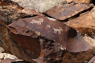
After regrouping, we hiked a few miles (all downhill) until we came to Petroglyph Gallery, which is often referred to as the “Sistine Chapel of Native American Rock Art.” We met an archaeologist at the Gallery that had hiked in from the north side and he gave us a tour of the Gallery and explained that the Gallery contained over 300 rock art panels with over 1,700 documented individual designs that had been created by what is believed to be native cultures from the Puebloans (Archaic Period) to historic eras after Europeans visited the area (one petroglyph appears to show a European on a horse). We were told that some of the designs may be 7,000 years old. Circular and rectilinear lines are the most common motifs in the Gallery, but there are also numerous anthropomorphs (human-like) and zoomorphs (animal-like) figures. This site is sacred to many Native Americans, so we were careful not to disturb anything. In addition to the rock art, there are also signs of Early American hunting blinds and milling operations in the canyon that are of interest.   


From the Gallery we had about a two mile hike to the vehicle. Part of the group went on the new trail (Trail #200), which bypasses the Class 3rock climb on the north side of the Gallery, and the rest of the group continued down the canyon to the junction with Trail #100, and then on to the waiting vehicle. The ride out from the north side of the canon is along a rock covered trail that requires a high-clearance vehicle to go five miles in about an hour, but everyone arrived home safely and reminisced about the great time that we had.