Friday, March 28, 2014

AronnieAdventure #0093 - Peggy Sue's Dinner, Yermo, San Bernardino County, California

The drive between Las Vegas and Las Angeles is not the most beautiful part of California, but there are some unique features along the way. Yermo is about halfway between the two cities and the home of Peggy Sue's Dinner, which is a great place to stop because they have a old-fashioned restaurant and ice cream counter just like the one at the Corner Drug Store that we used to patronize when we were kids.

Peggy Sue's Diner was originally constructed in 1954 using excess railroad ties and mortar from the nearby Union Pacific Rail Yard; and when completed, the building contained 9 counter stools and 3 booths.  Unfortunately, when Interstate 15 was constructed it bypassed Yermo, and Peggy Sue's closed for a lack of business.

Then, in 1987, a couple from Southern California, with an extensive collection of movie and TV memorabilia, purchased the property as a place to display and store their collection. To help attract customers, a 5 & Dime Store was added, along with an ice cream counter that served old fashioned ice cream, malts, sundaes, floats, and deli sandwiches. Most of the couple's collection consisted of items from the 50s and 60s, so the restaurant's slogan became "Eat to the Beat," as a jukebox blared out early rock music (Elvis, Jerry Lee, Johnny Cash, etc.). Over the years, the 5 & Dime Store has turned into more of tourist trap that specializes in nostalgic items, including a large collection Betty Boobs items. In keeping with the décor and theme, the restaurant serves a Patty Page Patty Melt, a Buddy Holly Bacon Cheeseburger, a Frankie Avalon Philly Steak Sandwich, and Fabian French Dip. 


Arriving in California, we picked up our granddaughter at her school and after giving me a big hug, she said: "Grandpa, you have less gray hair then when I last saw you!" Just as I was thinking that my diet and weight loss must really be working, she went on to say: "Now your hair is almost all white." I was about to disown her when she said: "But now you look so distinguished!" What a great kid - She should be a politician!

While we were in California our granddaughter was playing in a basketball tournament and we were able to watch three of the games. Their team won the first game by a large margin, the second game was won by 2 points, and the last game they came in second (of course, the last team they were playing consisted of girls that were two years older.) Between games, we also visited the USS Iowa. (Stay tuned for the next RonnieAdventure.)


Friday, March 21, 2014

RonnieAdventure #0092 - Silver Reef, Washington County, Utah

There are a lot of different stories about who and when silver was first discovered in the Silver Reef area, but it is known that the Smithsonian Institute called early ore samples that they examined from the area “interesting fakes.” The entire area is composed almost entirely of sandstone and everyone knows that you cannot find silver in sandstone. (Silver Reef is now recognized as the only place in the United States where mineable silver is found in sandstone.) It is believed that silver was first discovered in the 1860s, but it was about 1875 before people were convinced that the silver deposits were legitimate and various mining operations were started.

At first the area was called Bonanza City, but real estate prices were so high people couldn't afford to live there; so the miners started building “shacks” on a nearby ridge and called the community "Rockpile." However, with the arrival of families and businesses, the name “Rockpile” was changed to “Silver Reef” because the name sounded more sophisticated. The "Silver Reef" name was chosen because the buckled sandstone cliffs in the area give the appearance of an ocean reef.

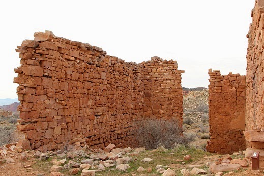
By 1879, 2,000 people lived in Silver Reef and the town had a mile-long main street, including hotels, restaurants, stores, a post office, 6 saloons, 2 dance halls, a hospital, 2 newspapers, 2 cemeteries, and a Wells Fargo Express Station. Of the original structures, the Wells Fargo Station is one of the few original buildings that remains intact. (The building is the oldest, continuously standing Wells Fargo Express Station in the World.)

In the brief period that the mines flourished, over 8,000,000 ounces of Silver were extracted from 37 mines in the area. To process the large quantity of ore, at one time there were five stamp mills operating in the area. Ruins of the Barbee & Walker Mill can still be seen on the side of a hill near the Wells Fargo Express Station.

During the boom days, mine tunnels were drilled at every silver outcropping that could be located along the ridges; so the area is now a large honeycomb of mine shafts. In 1990, the State of Utah closed 465 mine shafts to keep people from accidently falling down an open pit; however, there are still a number of open shafts in the area. 

The main mining boom was from 1875 to 1888, but mining continued on a reduced scale until 1901. The mines were subsequently opened twice in later years, but never to the same extent as the 1875 boom years. Silver Reef was then left to be a ghost town with its picturesque crumbling rock walls and foundations.

Today, Silver Reef can be reached by a paved road and there is a resurgence of activity in the area as new homes are being constructed in and around the old town site. The Wells Fargo Express Station has been restored and is now operated as a museum. The museum is only 1.5 miles from the freeway and it is open on Monday, Thursday, Friday, and Saturday from 10 AM to 5 PM; so it makes a great stop when traveling by on the way to Las Vegas or Salt Lake City.


Friday, March 14, 2014

RonnieAdventure #0091 - Harrisburg and Leeds, Washington County, Utah

In 1859 Moses Harris settled along the Virgin River in southern Utah and called the settlement Harrisville. Over the next few years, he was joined by several other families and the town’s name was changed to Harrisburg. By 1868 there were over 200 people living in Harrisburg; but then following several floods, Native American raids, and a grasshopper plague, people started moving “up-river” to the settlement of Leeds. By 1895 the town of Harrisburg was abandoned.

However, history tends to repeat itself, so real estate investors are now developing “Harrisburg Estates” on the old town site. But, investors should not worry because western United States is having a drought and the Virgin River hasn’t flooded in years!

 
In 1867 a group of immigrants from Leeds, West Yorkshire, England, moved to the area and named the settlement “Leeds” after their homeland. The area around Leeds has the longest growing season in Utah and is well known for its abundant production of fruit and sorghum. There are still numerous buildings in Leeds dating from the 1800s, including 15 houses still standing and in use along Main Street.

The Sarah Ann and William Stirling house is a good example of the period architecture and exemplifies the “Dixie Dormer” upper floor windows, which were popular during that time period. The house was constructed in 1876 at a cost of about $5,000.

 
In 1933 the Civilian Conservation Corps (CCC Camp #585) opened a facility in Leeds and more than doubled the community’s population of 200. The CCC nation-wide employed about three million young men in a “peacetime army” to work in our public lands. They were often referred to as the “Pick and Shovel Soldiers” because these were the primary tool that they used in the CCC construction projects.

The CCC men earned $30 per day, of which $25 was sent back to their family. In addition to their wage, they were provided three meals a day, a bed, medical care, and vocational training. It is estimated that about 40,000 illiterate men learned to read and write through this program.

Work projects were primarily located in western United States, which is where most of the public lands are located. The Departments of Agriculture and Interior planned and organized the work projects and the U.S. Army was responsible for transporting the workers and provided their training. In the10 years that the CCC was in operation, the men planted millions of trees, built miles of roads and trails, fire towers, campgrounds, and bridges. Many of the facilities that they constructed are still in use today.

At first the residents of Leeds were not certain that they wanted a CCC camp located in their community, but the workers were well received after the Leeds residents had the opportunity to meet some of the young men. The workers had a positive impact on the town’s struggling economy and the young men not only contributed monetarily to the local economy, but in their off-duty hours they worked on a number of local projects, including a community swimming pool.

Today, you can visit the Leeds Historic CCC camp and view a few of the remaining stone structures. The frame buildings were destroyed or moved after the camp closed, but some of the buildings may be reconstructed in the future to show how the men lived while they were in camp. 


Friday, March 7, 2014

RonnieAdventure #0090 - "The Journey" by Roy Purcell, Mohave County, Arizona

Roy Purcell was an unknown artist until 1967 when he painted “The Journey,” which contains symbols and imagery of Native American and World Mythology. “The Journey” is painted on canyon rocks located in the Cerbat Mountains near Chloride, Arizona. Since 1967 Purcell has created a large body of art works in various media, including watercolor, oil, pastel, ink, acrylic and pencil to express the world around him.

Before painting “The Journey” Purcell had been pursuing his Master’s degree in Creative Writing and Fine Arts and working as a miner to support himself. However, after completing “The Journey,” Purcell said: “I could no longer hide from myself. I had begun a journey of self-discovery from which I could never turn back.” He then accepted a job as the Director of the Mojave Museum of History and Arts in Kingman (Arizona), where he started doing etchings that would become his trademark. Purcell then moved to Las Vegas to become Director for the Southern Nevada Museum in Henderson and four years later he started working solely as a freelance artist.

In the early 1980s Purcell completed a number of monumental projects, which included the world’s largest engraving (“The Christ Light”) for the First Presbyterian Church in Las Vegas. He then went on to jointly create the “Bridge for Peace” project with the University of Nevada, State of Nevada, University of Tel Aviv, and the governments of Israel and Egypt; however, the governments of Israel and Egypt dropped their involvement before the project was finished due to tensions in the Middle East. The Nevada phase of the project was completed in 1984.

In the 1990s Purcell used his diverse talent and experience to help design the Atlantis Resort Hotel & Casino in Reno (Nevada) and then in 1997 he created a limited edition of etchings called the “Journey to Zion,” depicting the Mormon’s journey to the Salt Lake Valley. Following the “Journey to Zion” series, he created a 25 series of etchings depicting major episodes of Jewish history.

Roy Purcell is currently working on a series of etchings dealing with the Native American Legacy and their message for today’s world. His artwork can be found in museums around the world and in many private and corporate collections.